Fort Benton River Press

When I passed through Fort Benton, MT a few weeks ago, I was interviewed by an aspiring reporter/summer intern, Zach Brown, from the University of Montana. Here is the article that resulted, online copy is behind a paywall. Hoping to get ahold of a hard copy at some point:

Two years ago, Mark Fingerhut was on his honeymoon driving through Yellowstone National Park when he decided he was going to kayak from Yellowstone all the way to St. Louis, Missouri.

Fast forward two years and Mark is 38 kayaking through Fort Benton on his journey. “We made it through Yellowstone and to the headwaters of Three Forks and being there I was just like I’m going to do this trip from here someday,” said Fingerhut. Then the opportunity presented itself this summer.

For the past 13 years, Fingerhut has worked for Ungerboeck Software in St. Louis. “I kind of just asked for some time off, for a sabbatical and they were very understanding with me,” said Fingerhut.

Someone else who has been very understanding about his trip is his wife. “She’s totally on board she’s happy to support me.” A good friend of Fingerhut’s runs Timber Longboard Company back in Missouri and asked if he could build his Kayak. Mark had to drive his big wooden kayak and all his equipment out to Montana. She flew out to Bozeman to put him in the river and drive the truck back home. “She’s supportive she says awesome, take your adventure and in a couple years when I decide to do the Appelachian trail you can support me doing that.”

It sounds simple right? Get a kayak, water and some food, get into the river and away you go. Unfortunately, this is not the case. “When I first started sketching out plans for the trip I thought maybe it would be ten grand for everything included… that’s probably an overshoot and I’ll be a lot less than that but who knows?” Said Mark. He does have some sponsors to subsidize that cost though.

This trip is about passion. Passion for kayaking but also, passion for the water. “My main cause is I’m raising money for Missouri River Relief. It’s an organization that’s based in Missouri and their mission is to kind of connect people to the river.” Missouri River Relief holds river clean-up events, they host educational programs and in Columbia, MO, they will take every fourth grader out on the river for a day and show them around.

There was no exact preconceived plan that Fingerhut had, “I was just going to go as the river and whether dictates.” Mark is planning his trip to be about three plus months. He does have some people along the way that want to see him. “I have had a lot of friends and family say we want to meet you, where are you going to be on this date. I’ve kind of tried to put together a rough plan of where I’ll be and when.” Fingerhut knows his trip is going to go fairly quickly, forcing himself to move slowly to enjoy the scenery that is coming up along the journey.

You can follow Mark’s journey by keeping up-to-date with his blog, Paddle St. Louis, A Journey From Yellowstone to the Arch in Support of Missouri River Relief: www.paddlestlouis.com

The Boat Tunes Playlist

Early on in the planning for my trip, I made some decisions on how connected and how high-tech I wanted my experience to be. One of those decisions was to pack a small bluetooth speaker so I could listen to music and podcasts on the long days of paddling. I’ve been using Pandora as my music streaming service for years, but have only the free subscription. Counting on cell service to supply me with my music was not ideal. So I sprung for Spotify. With Spotify, for 10 bucks a month, I was able to download as much music as I possibly could fit on my phone. So in the months leading up to my trip, I downloaded as much music from my past as I could think of, and quite a bit of new stuff I was looking forward to listening to.

One pretty cool feature of Spotify is the ability to share and collaboratively create playlists. I think we were standing around before a hash prior to my trip and my good friend Matt mentioned we should get people to contribute to a playlist for my trip. Thus, the Boat Tunes playlist was born. The list was shared out with people who have Spotify, a Facebook thread was created with requests and the playlist began to grow. I did not look at it. I set a deadline for the night before I got on the water, the last time I’d have wifi to be able to download all the music. That night, I downloaded it all.

128 songs in all. Here are my comments and some funny anecdotes from listening to the Boat Tunes playlist off and on over the first month of my trip:

  • I exclusively listen to this playlist on shuffle/random. I leave it to the river gods to determine what I am hearing at any given time.
  • Someone, and I think I know who, loaded up the list with a bunch of Phish songs. I feel like every other song is a Phish song. And considering how long Phish songs are, 90% of the time I am listening to Phish. It’s not great.
  • I was paddling in some pretty big waves on Fort Peck Lake listening to the playlist when a Florida Georgia Line song came on. I make it a point to not skip over tracks, but in the process of immediately getting my phone out to skip this, I almost flipped my boat. Thanks, Louis C.O.C.K.
  • That same day, Surfin’ USA by the Beach Boys came out. You could hear my cackle in the nearby canyons as I surfed across the Fort Peck waves.
  • As I paddled among the amazing, world class fly-fishing waters of the upper Madison, weaving in and out of driftboats full of concentrating fishermen, Boats n Hoes came on. Perfect.
  • Each and every time Can’t You See by the Marshall Tucker Band comes on – and it seems to come on a lot, I smile, I rock out, and I am instantly in a Busch Light commercial. Thanks, Louis C.O.C.K.
  • Some contributors stuck with the water/river/boat/paddling theme for some of their songs. Others just added some pretty damn good music. Thanks, Laura.
  • Yes, Gloria by Laurie Brannigan is on the list and it has been played during and after the Blues Stanley Cup win.
  • Yes, dueling banjos is on there. Hardy har har.
  • Breathing Underwater by Metric? Whoa, things just got dark.
  • Careless Whisperer by George Michael. If Matt Frank had invested all the money he spends pushing this song up to the front of the line in bar jukeboxes, he’d be retired.
  • Colin added an amazing tune called Yes! We Have No Bananas a song by Billy Jones from the 1920s. Almost makes up for adding Cool for the Summer by Demi Lovato. Ugh, no.

This is a live and active playlist. If you have Spotify, you too can contribute glorious and awful music to my daily listening habits. Visit my link to this post on my Facebook page to get to the Spotify playlist link. I do need wifi to download the new songs, but it looks like I should have access the next couple days.

Thank you to Matt for the idea of the playlist and putting it together. And thanks (I guess) to the contributors for making my daily auditory experience a bit more interesting on my trip.

mf

Ode to Fort Peck Lake

Paddling out of the Upper Missouri River Break National Monument, who pretty much everyone agrees is the most beautiful part of the entire river, I was prepared for a change of pace and an increase in difficulty as I entered Fort Peck Lake. I’ve kind of lost track of the days, I am indeed on river time, I think it was last Wednesday when I made a quick stop at James Kipp campsite, successfully begged for extra water from two young outfitters who were pulling their boat out, and continued. I wanted to get as close as possible to the start of Fort Peck Lake – where the river current slows down, the valley widens and you suddenly find yourself in a wide open lake. I went about 10 miles, my maps had lots to be desired in terms of instructing me how far I could safely go. I didn’t want to encounter braided channels or even worse, running aground in nasty mud at the start of the lake very late in the day. I set up camp that night at a pretty rough spot – had to climb a mud bank to get out of the river, deal with weeds, mosquitos and a curious Bull Snake as I was setting up camp. I did enjoy listening to the Blues win Game 3 (I think) on the radio.

Fully rested, I woke up and prepared to take on the start of Fort Peck Lake. There was about 10 more miles of true MO River before the lake – I could have easily made it further the day before. Eventually, I encountered the main channel breaking up into side channels, beautiful islands of cottonwoods and willows everywhere. But still, current. I stopped mid-day to climb an amazingly perfect conical hill overlooking the start of the lake.

Later in the afternoon, I approached the start of UL Bend. This massive U-shaped bend in the river is notorious for shallow spots, dead end channels, out-of-nowhere winds and just being a challenge.

I encountered just the opposite. Oddly, the wind died down as the river widened. It was a sheet of glass for the most part. The river is higher than normal everywhere, including here, so I didn’t come close to running aground in shallow water. I even got a message from Norm later in the day asking if the river was up because according to his map, I was paddling across land. He also told me to keep paddling for 1.5 more hours to some great camping. I finally took out around 6pm at this amazing spot, close to the bottom of UL Bend:

The next morning, I was prepped for rougher conditions – wind and waves. I hear you don’t get a free perfect day on Fort Peck Lake. The first few hours were pretty amazing as well, the sun rising over a very calm lake as I paddled around the bend then turned north. Mid-morning, the winds picked up and I experienced open water waves for the first time. I started to get a feel for the boat and how it navigated rougher water. I didn’t panic, just tested how far away from shore I could go and still feel comfortable. How I adjusted my boat via the rudder or directional paddling depending on what direction the waves were coming from. I stopped for a snack mid-morning and caught my breath and stretched my legs. By around 1pm, I was spent. I pulled into Devil’s Creek campground and called it a day. Temperatures were approaching 90 degrees in the sun, so I took my hammock up the hill to a pavilion and relaxed with my journal and those of Lewis and Clark, taking in all they experienced when this massive lake was just a simple river. I talked a bit with a retired journalist and investigator Ted who was doing some fishing there, who early the next morning sent me off with a cold beer to be enjoyed later that night, as well as a promise to send me a few photos he took with his nice camera. Today’s challenge was to try three separate big water crossings:

From south side to north side, then at the big bend, from the west side to the east side, then at the next bend, from the south side back to the north side. Winds were from the south generally this day, so my south to north crossing was a wildly entertaining ride on the waves. They weren’t terribly big, maybe 1 – 2 ft, but my adrenaline was definitely elevated as I made the long crossing. Another hot day, I stopped briefly to immerse myself in the lake and hike up the hill to get a view at Bone Trail Recreation Area:

It was still early afternoon so I pressed on for about 8 more miles until the storm clouds started to approach behind me. I had heard from messages and weather updates that it was supposed to storm, so I found a sheltered cove in plenty of time to set up camp before the weather rolled in. I also installed the extra guy lines on my tent connected to 12″ stakes to ensure my tent could ride out most storms. I was treated to a spectacular display of storms rolling in just north of me, getting hit by a second round, posting up in my tent making sure it stayed put and staying dry. Even got a rainbow as I laid down for bed.

Next morning I was out early again and did the Go Pro video before the wind got strong. At one point, I had no sense of where the waves were coming from, just trying to paddle through and not tip over. I pulled off after 10 miles and decided to wait for the winds to go down. I spent the time climbing a nearby mountain where I got some much needed phone reception to post some updates. At the top of the mountain, I noticed the wind was slightly less and the whitecaps out on the water were more sparse. Back into the yak I went and covered another 14 miles into the early evening. I even tossed the fishing line in later in the day and managed to pull in a beautiful Northern Pike. I don’t portend to be a fisherman, I was shitting my pants, trying not to kill myself or the fish. He eventually set himself free back into the lake, I didn’t plan on keeping him anyway. Camp was a lovely spot around the bend out on the end of a nice coulee.

The next morning was windy, so I opted for the Graveyard Hill adventure previously posted. But instead of staying off the water all day, I had the burgers and beers of Fort Peck Marina flashing in front of my eyes so I paddled on. I wasn’t making the Marina that night, but I got to Pines Recreation Area, after crossing 5 very windy and wavy inlets – varying from 1 to 3 mile open water crossings.

I was mentally and physically exhausted after hiking all morning and surfing on bouncing waves all afternoon.

I woke up planning to finish the lake and went hard after it. There were 5 more open water crossings, the last being the most difficult – a 4 mile paddle to near the dam. Waves were big, 2 – 3 ft and some whitecaps. Winds were generally from the northwest so I managed to keep my boat positioned ideally, but there were some harrowing moments. And as I made the final turn into the cove of Fort Peck Marina, wouldn’t you know it was straight into the stiff headwind out of the northwest, the last few hundred yards of paddling had my arms and shoulders burning. The burger and beer for a late lunch never satsified me much as these did.

130 miles over 5 days. I think if had one of my other kayaks, or a canoe, I would have certainly had to take a day off here or there on the lake to wait for the wind to go down. Note that I didn’t put myself in any dangerous situations. Other than the morning I pulled off after 10 miles, I felt challenged but in control. Handling the waves in what is essentially an ocean kayak was a steep learning curve, but one I feel I navigated successfully. I’m no Peck expert, but from what I gather, the conditions I experienced were average. I hear many stories of MO River paddlers that are stuck on shore for multiple days at a time waiting for the wind to die down in order to cross safely. I have two more big lakes where I am sure to be tested further, but overall I am happy with my experience on Fort Peck Lake. I appreciate its power, unpredictability and certainly its beauty.mf

The Ballad of Charlie Marrs

Saturday morning, I awoke in my rattling tent around 6. The wind was blowing in from the Northwest at around 15 to 20 mph. Waves were crashing onto the beach I was camped on, just at the edge of my boat pulled up on shore. I considered getting back onto the water right away, another full day on Fort Peck in the wind and the waves, confident I’d be able to paddle through it, but not really looking forward to the effort and concentration needed.

I checked my GPS map. I was camped on the very tip of a coulee – Eighth Coulee – sort of a long ridge/peninsula that juts into Fort Peck Lake. Way up at the top of the coulee – maybe a good 4 miles away as the crow flies, I see a little marker – Graveyard Hill. At that moment I decided a walk to whatever Graveyard Hill turns out to be was better than a rough day on the water. I packed a small bag with snacks and water, grabbed my hiking pole and set out.

The first mile or two of the walk, I am simply trying to solve the maze that is the ridgeline that will lead me up the coulee. After all, I was walking on top of what used to be a pretty substantial ridgeline that overlooked the Missouri River valley prior to the dam being built in the 1930s, which turned this into a floating labyrinth. You climb a hill, determine which is the best route that will get you further up the ridge, then descend and follow what your mind remembers before you climb again. I saw what I assumed was Graveyard Hill a ways in the distance, so I tried to keep that as my objective. The treeless peninsulas and ridges soon gave way to a pine forest, which showed signs of having burned in a wild fire recently. I was watching every step closely, aware of the risk of upsetting a resting rattlesnake, though not too concerned as it was a pretty chilly day, or turning an ankle on a rock or root. Consulting the GPS map, I had to correct course a few times to stay on track for the Hill.

Eventually, I started climbing over a razor thin ridgleline – looking out to on both left and right miles out into the lake inlets. Graveyard Hill was getting close. One last climb and I was there. The highest point for miles around. At first there was nothing. Then I saw a few things that nature didn’t have an explanation for – approaching them I noticed there were three Army Corps survery markers:

Interesting, perhaps, but this wasn’t the Graveyard advertised. Nevertheless, I took in the incredible view in the gusty winds for a bit, then started back down the coulee.

Taking a slightly different route going down, I looked to the next ridgeline and noticed something else not quite explained by nature. A small fenced off area – protecting a small plot of land from invading cattle that sometime use the pastures. For a moment, I didn’t think much of it and continued on my path. But the thought that’s came to me time and again on this trip – you are here in this place only once, you have unlimited time and no one is telling you what to do – I walked up to it.

4 poles stuck in the ground connected by wire, surrounding a gravestone:

I read the headstone. My mind was going 200mph. Charlie Marrs. Young guy, 32 years old. Cowboy. Struck by fricking lightning on his horse – what an awful way to go. Then 88 years later, some grandnephew gets wind that his great uncle was an ‘old time cowboy’ and decides to plant this headstone. Certainly ol’ Charlie Marrs isn’t buried here. My best guess is that young Don best approximated the spot where Great Uncle Charlie was struck down and came up here to plant this. It’s absolutely possible the exact spot is somewhere nearby, possibly 200ft under the lake that wasn’t there in 1905. But it was an amazingly beautiful spot overlooking the lake, on an extrememly remote ridge, where I doubt anyone has randomly run across this before.

When I’m back in civilization, I would love to try to track down Don Weibert, or Great-Grandnephew Jamal Weibert and get the full story on Charlie Marrs, and what’s the story behind this memorial marker. I am certain the story behind Charlie Marrs is 100x more interesting that the story of me locating his memorial stone. My long hike up to Graveyard Hill didn’t turn out to be a disappointment. If I was a singer or someone who writes songs, you bet your ass there’d be a tune coming out that lamented the unfortunate ending of one of the true old time cowboys, Charlie Marrs.

mf

The Biggest Thing

On my 4.5 mile walk back from Fort Peck Dam to my campsite (correct, this place wasn’t built with pedestrians in mind – more on that later), I got to thinking about the single biggest human-created object I’ve ever seen. We can quickly get into a debate on definitions of ‘big’ and of ‘object’: is a city an object? The Great Wall of China? Do a lot of little objects make up something larger? Does big mean intricate, complicated?

On a restful Monday afternoon, over a few beers and a sunny, perfect day in Montana, I’ve decided this is the largest human-created object I’ve ever seen:

It’s hard to see but it’s there. The Fort Peck Dam. Lake on the right, the dam curves from the center, out to the right, then back to the left again. It’s the world’s largest hydrollically created dam, which I learned today means they dredged silt, sand and gravel from the river bottom to build it. The loaded all that slurry into a single massive pond, let all the water drain and let it dry out, rinse and repeat, layer upon layer until you have the dam. It’s 4 miles long and 1 mile wide at its base. It took 7 years to build, at its peak employed 10,000 workers making 50 cents per hour, killed 31 guys during contruction (an excellent safety record for its time), and cost what an average major league pitcher signs a contract for today: $84 million!

In my definition, this object was built to serve a single purpose, plus one big caveat is that you can see pretty much see the whole thing at once. That would disqualify the Great Wall (not counting from space – see I can qualify this however I want, this is my blog).

I’m trying to wrack my brain to think if I’ve ever seen anything bigger in my life. Have you? What would that be?

mf

Reflections on the Upper Missouri River Breaks

Writing this post on Wednesday, June 3rd. Also, I may have to add the photos back to this post at a later date.

A week ago today, I put on at Carter’s Ferry and paddled 16 miles to Fort Benton, mile 0 of the 149 Upper Missouri River Breaks. This stretch of river is what most consider the most spectacular scenery on the entire Missouri River. The first half, generally from Coal Banls Landing to Judith Landing are the famous “while cliffs” – sandstone walls and natural monuments on both sides. So much to take in. Then after Judith Landing, the personalilty of the Breaks changes. It has more of a Badlands feel to it – rocky, muddy cliffs, but no less beautiful. As the Badlands is one of my favorite National Parks, I think I enjoyed the lower half the best.After camping with my friendly snake at Judith Landing, I put in a full day of paddling, stopping at a few interesting Homesteads – more on that. Around 5pm, I pulled into Gist Ranch – normally an excellent homestead to check out. But I think what happened is that the winter ice jams took out the cattle fences keeping them out of the campsite. The actual camp was a wreck with cow dung, a stench and generally just torn up ground. I paddled another mile or so to Snake Point. Still a bit torn up from cattle, but not as bad. The Breaks guide said this was the starting point for a short hike up a Badlands-type mountain, from where Meriwether Lewis spotted the Rocky Mountains for the first time. I had a relaxing dinner and evening watching the sunset over the river, and was even treated to a low-flying single engine plane right through the river valley to coincide with sunset – look to the left, it’s there:I set my alarm for 5:15 but ended up not neding at as it starts to get light this far north before 5am. I jumped up, grabbed a Cliff Bar and water and climbed the hill. 1000 ft and a pit stop to take my morning constitutional is a self-dug hole later, I was standing at the exact spot where Meriwether beheld the snow-capped mountains that would later nearly put an end to their westward exploration. No mountains were to be seen today, I was told the day before that the increased haze was due to wild fires in Alberta, Canada.I took a few photos of the scene as the sun came up over the mountains. Pretty sure I’ll be framing this panorama:Later that morning, I stopped by a Homestead that wasn’t marked on the map. If it gets published when I have reception again, I had an Instagram post that gave a short explanation of Homesteads along this part of the river. Basically, in the mid to late 1800s, the US government basically gave away tracts of lands in order to get people out west, settle the land and, ahem – move Native Americans off the land. While some stuck it out and made a life on the wide open plains through farming or raising livestock, many others weren’t able to sustain a life with the harsh Montana weather and conditions. Some of these Homestead sites can be found along the river here. Some are actually still in use as working farms, many others are just ruins of the old farm sites. You are able to stop and walk around in them. Some of the images are pretty stark. As I explored a few on my own, I had feelings of insignificance and impermanence. Here were homes and workshops of people whose lives were here or 10, 20, 30 years. And then it was done. They moved on to something better, something easier. And here were the remains of their lives and their work for that period of time. Captured in history.Another site I passed later that day was the Nez Perce Trail. While it isn’t a specific site you can stop and take a picture of, the map I was following was marked where the trail paralleled the river and eventually crossed over and headed North. As the young US was expanding westward, the Nez Perce signed a treaty to move to 7.5 million acres of land in Montana and further to the Northwest. As the 7.5 million acres became 1 million, 300 men, women and children of the Nez Perce refused to sign a revised treaty and tried to make a run for the northern border of Canada. Pursued by US troops, they were eventually tracked down, some killed and the rest forced to reservations. As I paddled by where these 300 tribespeople marched along and over the Missouri River, I reflected on the dark parts of our nation’s history, the sacrifices and horrible incidents that happened during our nation’s rapid expansion. Certainly, I’m proud to call America home. But I feel like educating oneself about the horrific things that got us to where we are today are a necessary part of being American.

When people talk about paddling the best parts of the Missouri River, many are referring to the Upper Missouri River Breaks. The incredible sights and scenery as well as the rich and plentiful wildlife along the way is matched only by the history to be found along the way. For someone who loves nature as well as history, this was a spectacular few days and I can only hope to make it back here to paddle this stretch again someday.

mf

Update from the Breaks

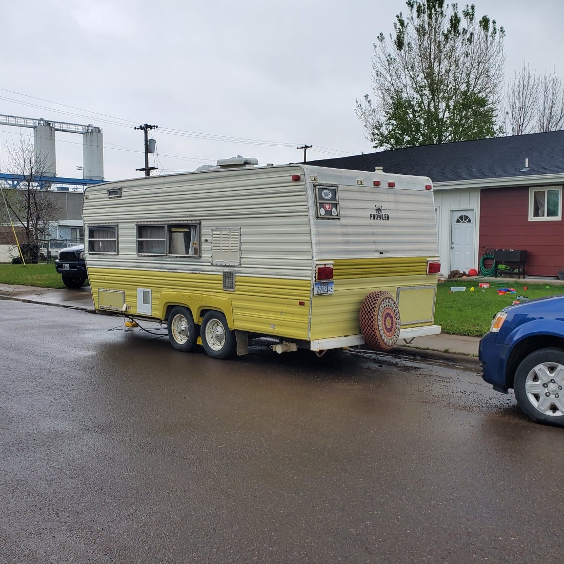
Post written June 1, 2019 – not certain on when this will be able to post. Also, the photos I wanted to include in this post aren’t working so I may have to add back in later.

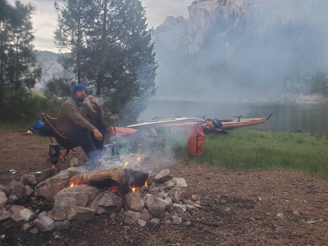
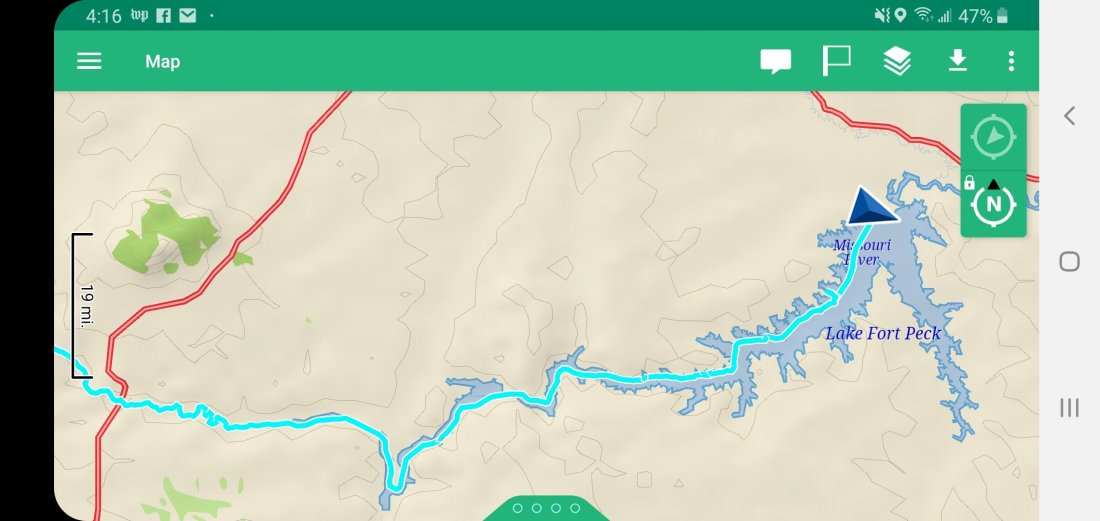
Currently, I am sitting at a picnic table at the campground at Judith Landing – at mile 88 of 149 in the Upper Missouri River Breaks National Monument. Just had a very satisfying dinner of dehydrated ham, beans, ramen and sauerkraut. Got a little nip of whiskey next to me, I found the Blues game 3 of the finals on the radio and just started a fire to keep the bugs away. It’s been a busy few days since Great Falls.Wednesday, my plan was to prep my gear and food for the coming weeks, then catch a ride from Great Falls to below the Falls with my shuttle at around 2:30pm. Knowing that I was going to need to bring a lot more water with me than I had during the early part of the trip, I had to pack everything as efficiently as possible, using every square inch wisely. Around 11:30 I got a call from a local Montana number and answered. It was Casey at local TV station KRTV. When I stopped into Montana River Outfitters the day before to get some advice on the trip, the owner Craig apparently called a few contacts in the media and told them about my trip.I walked around the corner to Miss Kitty’s coffee shop and met the reporter who did a pretty quick interview. I told her she was more than welcome to spice things up with any photos or video from my web site or Instagram.

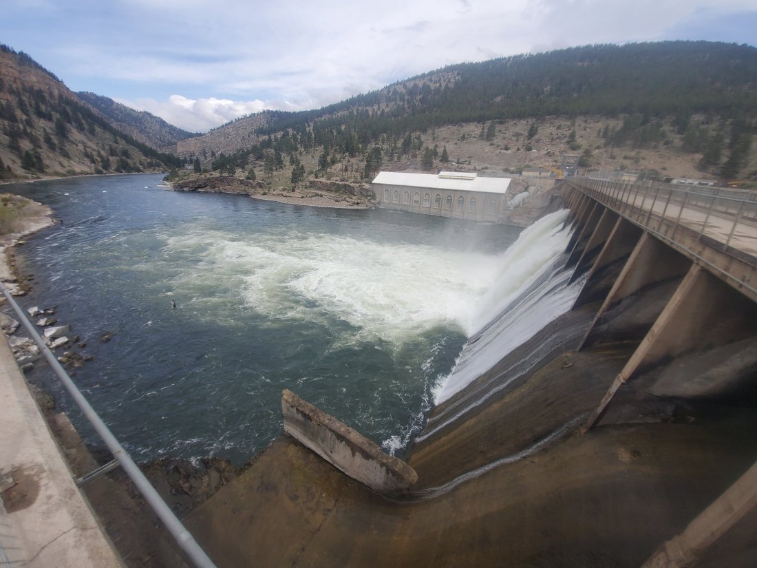
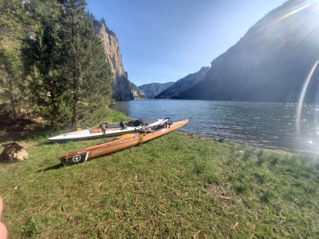
At 2:30, Phyllis and Jim Meade pulled up in their small truck with a substantial boat rack. Jim has been invovled with the Medicine River Canoe Club for many years. As the popularity of canoeing has given way to kayaking and stand-up boarding in recent years, they unfortunately had to dissolve the club in the past year or so. However, Jim and Phyllis will still dutifully portage Missouri River Paddlers around Great Falls. When I signed Jim’s clipboard, I flipped back to previous pages to see the veritable who’s who of MO River paddlers. Names I’ve heard, people I’ve talked to, peoples’ who’s books I’ve read or plan on reading. I felt honored to add my name to Jim’s list. They drove me to the most easily accessible put-in below Great Falls – at Carter’s Ferry. There are a handful of these really old ferries on the upper Missouri – big metal pontoons capable of carrying a car or two – and are pulled across the river on cables, that if you aren’t paying attention when you paddle through, you might just knock your head on…

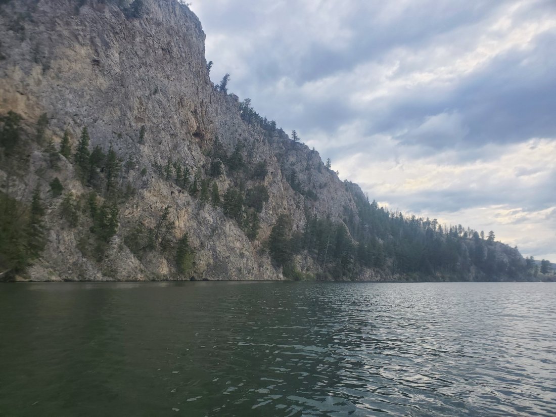
I put in at Carter’s Ferry on what was easily the warmest day of my trip so far – 80 degrees and not a cloud to be seen. The 16 miles to Fort Benton was beautiful – the river cuts a pretty deep canyon in the plains a few hundred feet above. There were many cliffs of different colors based on the types of rocks and dirt slowly being eroded by the persistent Missouri. Without paddling too much at all, I made the 16 miles in less than three hours.In Fort Benton, I pulled into the fantastic canoe camp, where I was the only one there to enjoy the ample water spiggots and even hot showers! I strolled the mile into town to grab some dinner. I ended up at the local VFW – the second night in a row at a VFW – and happened upon a hot dinner, some cold beer and the hockey game on TV. I got to talking with the bartender, told her what I was doing and then was introduced to her mother and a few friends further down the bar. At that point, I was getting notifications that my news story had hit the web, so they pulled it up on their phone and were, what can I say? Impressed. Had a good walk back to camp after the Blues won in OT.

The next morning, I visited the excellent Interpretive Center for the Upper Missour River Breaks. Fort Benton is mile 0 of the 149 miles of the National Monument. I watched a short video where I was reminded that the Missouri’s course owes its winding and circuitous nature to our last ice age. Originally, the Missouri headed due north to Canada and emptied into the Hudson Bay! After the museum, I met up with Zach, who is interning at the Fort Benton Press from the University of Montana. Norm Miller had a contact at the weekly local paper and let them know I’d be passing through on my way to St. Louis. Zach and I talked a lot about my trip, he asked some pretty darn good questions, and he sent me a link to his band on Spotify – that was off the record.

After a few more errands and lunch in town, I headed back to camp for a quick shower then packed up my boat to shove off. Just before I got in the water, I shot Zach a text. As I paddled the mile from camp back down to Fort Benton, Zach set up his camera on the bridge to grab a shot for the article. I’m eager to see what kind of article Zach is able to put together.

I can’t say enough good things about Fort Benton. It’s a very historic town, very significant in the history of Montana and the Missouri River. The places and the people were fantastic!I paddled through the afternoon, around 19 miles down to a primitive campsite at Black Bluffs rapids. All the primitive campsite means really is that there’s a sign and a small fire ring, which I didn’t use. Most importantly, there is some grass that’s not out of control where I can set up my tent and not worry about insects or snakes. I spent the evening listening to far off thunder and watching the menagerie of birds come and go along the cliffs opposite my camp.

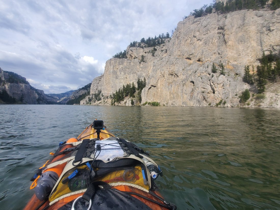
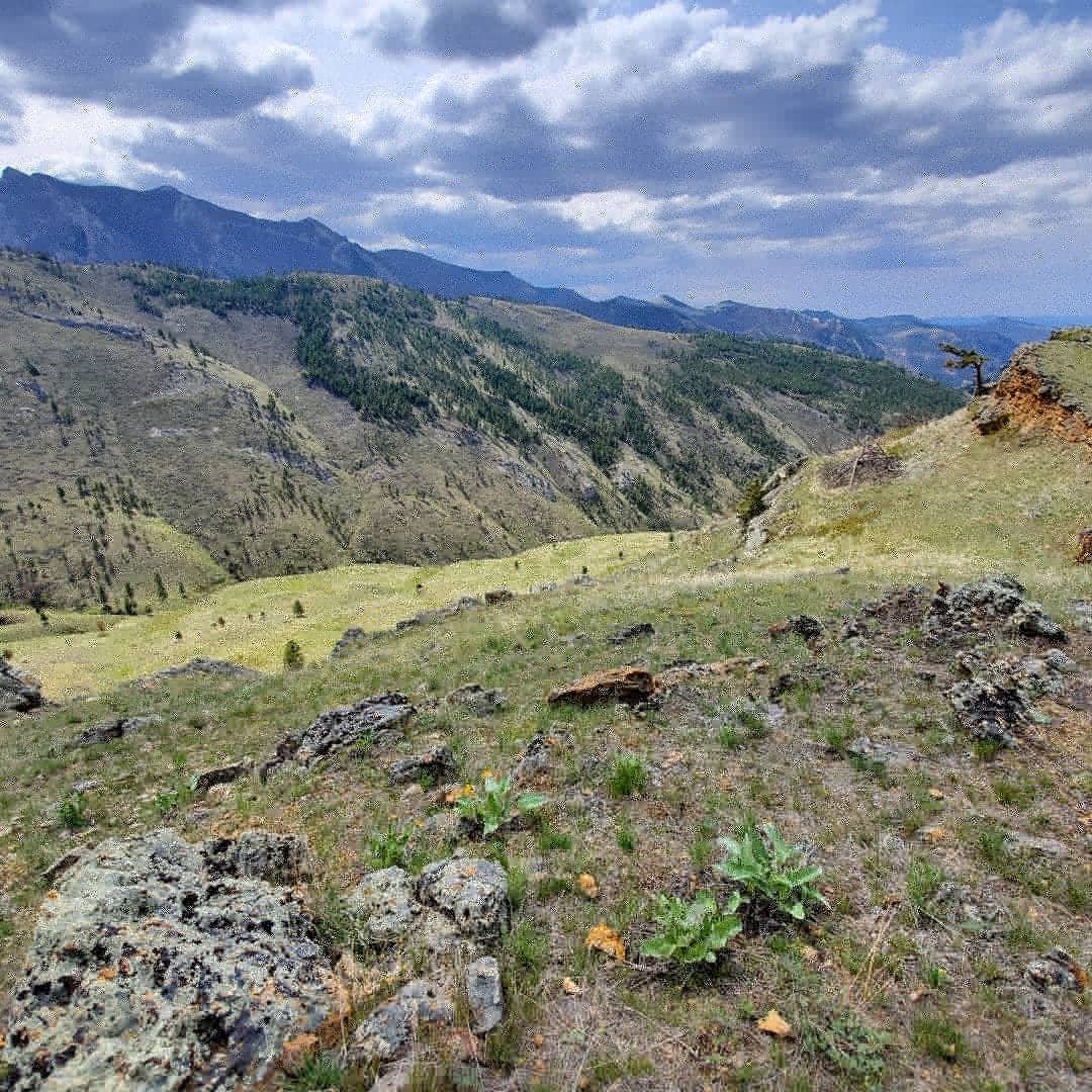
I was up early and on the river by 7 the next morning. About a mile down from my camp was Decision Point. It was here that the Lewis & Clark party paused for 10 days to determine which was the true path to the mountains – the (to be named) Marias River or what was indeed the Missouri. Contrary to the opinions of the majority of the men, L&C eventually decided correctly to continue up the Missouri. I climbed a nearby hill to take a look at the confluence and the helpful signage noting the spot. Then from about 9am to 3pm, I was covering a lot of miles – pausing only for a few minutes in Coal Banks Landing to register as a paddler of the Breaks.

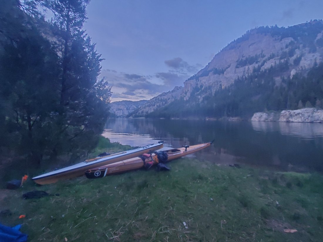
I pulled into Eagle Creek campsite at Norm’s suggestion – not only a nice spot to camp, but opportunities to explore some slot canyons and ancient petroglyphs nearby. Plus, May 31, 1805, the Lewis & Clark party camped here. That’s right – 214 years to the day – yours truly is camping on the same spot. Apparently, there is a marker that specifies their exact campsite, but I was unable to access it because, appropriately enough, two bald eagles were aggressively protecting their nearby nests, and gave me a pretty good tower buzz when I got close.

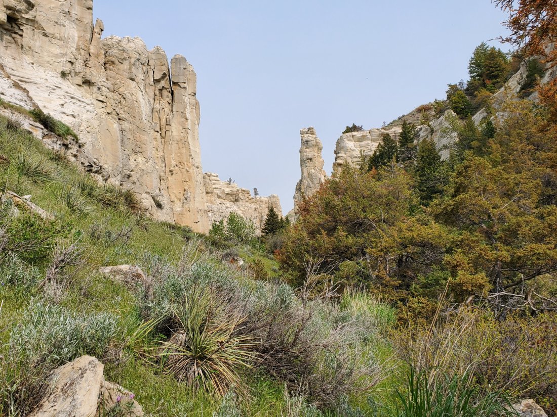
On my way to explore the slot canyons, I ran into a group of 4 people who were also camping at Eagle Creek. After checking out the spectacular sandstone passageways and towers, I talked to the crew of 4, all from Colorado. Carol, a retired science teacher, Cora, a nearly retired BLM employee, then husband and wife Chris and Steve. I told them what I was doing and they invited me to join them for venison stew for dinner, followed by cherry tart for dessert. They plyed me with whiskey as well, and we spent an evening around the fire exchanging stories. Steve even sent me off with a small bag of his own elk jerky.

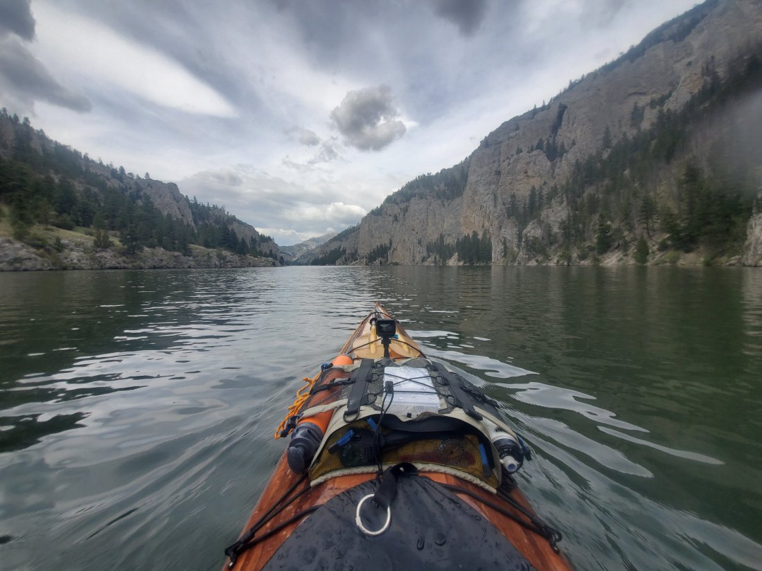
I was up again early and back on the river – a few miles down was one of the major landmarks of the Breaks – Hole in the Wall. I parked and climbed the rocky trail up to the top of the ridge. Me 10 years ago probably would have climbed out onto the actual Hole in the Wall, alas not today. I spent a few minutes at the top and managed to get some good photos of another family passing by in two canoes. (And check out that hawk photobomb, straight flexin’ and struttin’.)
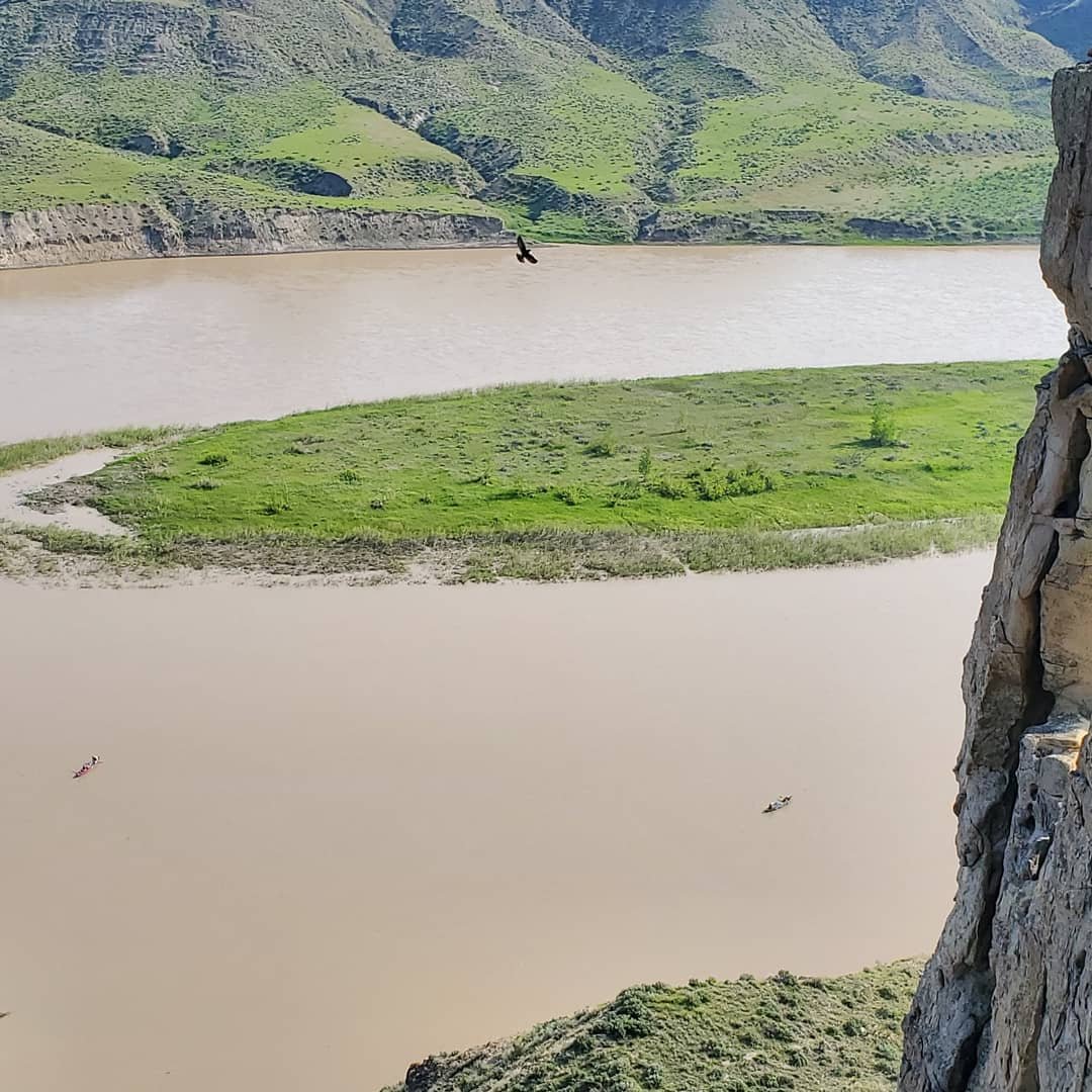
I played with the Go Pro while paddling the rest of the day. I did take another mid-day pit stop to hike back up into a couple more spectacular canyons.As the day got later, I motored on to Judith Landing, encountering a completely emtpy campsite except for a big old snake – can anyone identify what this is? And should I be concerned about sharing a camp with him?
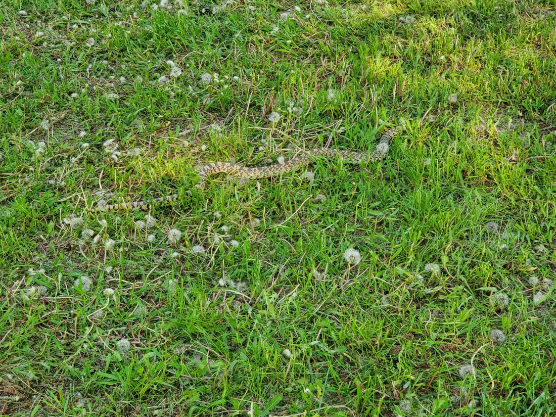
As I mentioned, finding enough drinkable water is a challenge on this part of the river. A few campsites that would normally have water suffered damage during the abnormally cold and icy Montana winter and their water supplies are shut off. I topped of my approximately 7 gallons of cpacity at Fort Benton and have been trying to go slow. They say you should consume at least a gallon a day. Luckily, Norm put me in contact with an outfitter in Fort Benton, and she told me where I could find a secret stash of water here at Judith Landing. Sure enough, shortly after I arrived, I located the old cabin, then a really old, disconnected gas station ice machine behind the cabin, inside which I found about a dozen large casks of drinking water! Sweet relief! I wasn’t running low on my supply, but I got more confidence topping off my supply, not knowing when will be the next opportunity to re-supply.Also note that today was the first day (and probably pretty much every day after today) I immersed myself in the river after a long hot day of paddling. Sweeeeeeeeeeeeeeeeeeet Relief!

mf

Rest and Respite in Great Falls

I had planned on taking my first few no-paddle days for the trip when I arrived in Great Falls, MT. My arms weren’t super sore when I got here, but I could feel they’d benefit from a day or two of little to no use. My main contact in Great Falls had been a local Hash House Harrier. Long story short for those that don’t know, the HHH are an international ‘drinking club with a running problem’ located in almost every medium to large sized city in the world. I’ve used it as a method to meet new people with common interests in other cities, to get intelligence on where to go, where to stay, where to get good beer, etc.

Anthony let me stay in his vintage camper out in front of his house.

Electrical was hooked up but not water so I had to get a little creative and become a frequent customer of the coffee shop around the corner. I paddled into Great Falls on Sunday morning, it was rainy and cold. Anthony picked me up and we somehow found a way to balance my 20ft kayak on the roof of the cab of his pickup truck for the short ride back to his house. Later on that day, the local Hash group was playing sloshball – a form of kickball infused with cheap beer and a lot of fun. It continued raining hard all day, stayed in the 40s, but sloshball went ahead as planned. We all had a blast splashing around on a muddy field, chasing a kickball, downing beers and generally having a great time.

We adjourned to a local brewery for post contest refreshments than back to Anthony’s house for some more great food cooked by his wife Nikki. I truly treasure the HHH community both at home in St. Louis and in other places I’ve visited throughout the world. What an incredibly fantastic luxury to have to be able to have instant friends and people who will go out of their way to help you with anything you need in almost any place you find yourself in.

The next day was Memorial Day, and the forecast was for more rain – all day and more cold. The length of my stay in Great Falls was seemingly dependent on the arrival of my first re-supply package. Mainly food and a few other small items I’d need to ensure I’d be able to continue my trip fully stocked. Through some snafu with UPS, I learned my box is not expected to arrive until this Friday – not for two more days from today! I spent Monday afternoon having a couple beers at a local brewery and trying to come up with a plan. After a few iterations, I decided I was going to wait for Tuesday, when the weather was expected to be excellent, and when all the attractions and businesses in Great Falls would be back open for business. I’d then determine if I really wanted to wait until Friday for my package, or buy the stuff I needed at the local WalMart Supercenter and get back on the river.

Yesterday was glorious! Anthony loned me a mountain bike to get around town. After my morning visit to the coffee shop, I headed to the river and the Lewis and Clark Interpretive Center. This is a fantastic museum in Great Falls that covers Lewis & Clark’s entire journey in 1804 – 1806 and beyond, with a pretty good focus on their time in and around the Great Falls of Montana, and their incredibly difficult month-long portage around the Falls. I dodged the kids on field trips at the museum and really enjoyed it. Then I biked down the hill to Giant Springs State Park – an amazingly crisp and clear spring on the banks of the muddy Missouri. The Spring forms what some consider the world’s shortest river – the Roe River at 201ft long. I spent a few more hours biking the excellent bike trail system along the river around Great Falls – some photos of the day on Instagram.

At some point in the day, I made up my mind to proceed on with my trip and not wait for my package. I contacted a few folks about getting a ride past all the dams and falls with my boat to continue on my trip and I have that arranged for this afternoon. Yesterday, I also met up with a guy from Great Falls who is considering a MO River trip in the next year or two so I talked to him for a while about planning and all kinds of stuff. I swung by an army surplus store to procure 12″ tent stakes for what Jim Emanuel promised I would encounter on the Great Plains: 80 – 100mph winds that my tent wouldn’t have a chance of standing up to without. Then I made a dreaded trip to Walmart to purchase food that would last me until my next re-supply box, along with an additional water container as this next stretch of river will be very limited in provisions and refill opportunities.

By the end of the day, the bike seat ensured my butt was in pain. Anthony invited me with his family and some friends to 50 cent wing night at his local VFW, and we had a wonderful time. Today is another fantastic day weather-wise in Great Falls. My shuttle is coming to pick me up around 2pm, then I should be on the river by 3:30 or 4. I’ll paddle for a couple hours to a campsite at Fort Benton, MT. From there on, I get into what will likely be the most scenic portion of my trip – through Missouri River Breaks National Monument. I’ll take my time, do some exploring and hiking in the canyons and cliffs along the river. From there it will be onto the first big lake – Fort Peck. Phone reception looks to be extremely limited over this stretch so I’ll likley be off grid for a couple weeks.

Spirits are good – mind and and body seem to be in good shape after R&R in Great Falls. Fingers crossed that the weather may have finally made a Spring-like turn for the better.

mf

Looking Ahead

One of the very first things I did when I put pen to paper on actually doing this trip was to write down every major category of planning that would need to happen to make this adventure happen:

UB Exit (my job)
Navigation Planning
Transportation
Supplies
Paddlers
Money Coverage
Budget
Re-entry
Research/reading
Blog
Emergency Plan
Insurance
Communication

While I didn’t use this as my strict outline for actually doing the planning, one item on the list came up today: Re-entry

It’s kind of an odd thing to think about two weeks into a 3+ month trip. But my first off day of the trip is today, I’m sitting in Mighty MO Brewery in downtown Great Falls enjoying a few beers as the cold rain continues to fall, and a very interesting article was posted on the MO River Paddlers facebook page.

http://erikelsea.com/post-expedition-blues/

The link is a translation to an original article by Martin Trahan, a Canadian explorer who paddled across the entire US, including the Missouri River last year. While his trip was about 9.75 times more epic than I expect my trip to be, including PTSD from riding out Hurricane Michael along the Florida gulf coast, Martin writes a truly heartfelt and revealing article about the experiences when an epic adventure comes to a close, and one returns to their “normal” life.

In thinking about my trip, it was something I was aware of, somehow. I can’t recall what prompted me to add ‘re-entry’ to my list of planning items for the trip, but it’s there. The people who have completed the entire Missouri River descent before me come from a wide variety of occupations and lifestyles. Some are retired, some are full-time adventurers, some are just taking a break from busy careers – probably the category with which I most closely identify. Going back to sitting behind a desk after 3+ months of paddling down a river, sleeping outdoors (almost) every night, and leading almost a 100% different life than what I am accustomed to is quite a change. It’s impossible to know how I will feel after the trip, how well I’ll be able to re-integrate back into normal life, or what other types of insane ideas I’ll have for how to continue to scratch the adventure itch that I know will be there in my life after this.

Not sure what the point of this post really is, probably just some ramblings after a couple beers on a rainy afternoon when I am more content to be here than out on the river. Certainly thoughts to keep aware of and on the horizon as I round the next riverbend and tally up the river miles.

mf

Through the Gates of the Mountains

When Lewis and Clark and their party reached the Rocky Mountains, they reached a point at which they did not see a way the river made its way through the mountains. The river makes a series of sharp turns around dramatic cliffs and mountains, hence the Gates of the Rocky Mountains. This was a place I was looking forward to experiencing since the very early planning stages of my trip. And although I’d be approaching the Gates from the opposite side that L&C did, the experience was no less awe-inspring.

I had the pleasure of paddling this stretch with Jim Emanuel, who had paddled the entire Missouri River, and kept on going to New Orleans, last summer. He was very familiar with this stretch of river and was an amazing guide. As an avid fisherman, he also made sure I was equipped with the best lures and bait for doing some real fishing on this stretch of the river.

Jim’s wife Vicki dropped us both off at Hauser Dam. We immediately had to load our gear in our boats and on our carts and roll them down a hill to the put in below the dam.

Hauser Dam

From there, Jim and I liesurely paddled and fished for the first 10 or 12 miles. I was only slightly alarmed when I heard the sirens going off at the dam, indicating an increase in water release. I learned they even sound the alarm if only releasing very small amounts of extra water, so it’s usually fine to ignore them. We fished for the better part of the day, me with absolutley no success and Jim with pretty decent results – a nice rainbow trout.

Eventually, we made our way into the wide open Hauser Lake and the upstream entrance to the Gates. Late afternoon light made for amazing sights as we entered the dramatic canyon.

I even got to safely check off an item I’d been wanting to experience on my list: to see a bear. As we entered the canyon, halfway up one of the hillsides was a black bear with its cub. I got a pretty good look with my binoculars. We paddled a few miles into the canyon before finding what’s probably the best campsite I’ve ever stayed at. Jim and I set up camp, built a fire, enjoyed a few beers and some nips of whiskey, shared good conversation and some warm dinner, and were in bed before it even got dark.

In the morning, we paddled about 3 miles down to Mann Gulch: another item I’d been looking forward to during the planning for my trip. In 1949, smokejumpers fighting a wildfire in Mann Gulch were overcome and raced to the top of a gulch to try to reach the ridge to escape the fire. 13 young men died in the fire, 11 not making out out of the gulch. Two more crested the ridge only to die from their injuries.

Jim and I made the 3 mile hike up the picturesque valley. Nearing the ridgeline, we began to see crosses and monuments that had been set up at each spot where a young man had died. We walked to each cross and paid respects, much more real for Jim as a life-long firefighter. We made our way to the top of the ridge and looked down on the other side to the incredible views below and the two crosses down below on the other side. As horrific as the tragedy was, being there in such an incedible place was quite a juxtapostion. The eternal resting place of these 13 men is beyond description in its beauty. It was a truly moving experience for all these reasons.

After we descended, Jim and I had a pretty long day of paddling ahead of us, through the rest of a serene and calm Holter Lake, yet another portage down below Holter Dam before setting up camp where the Missouri becomes a river again. A truly inspiring and unbelievable couple of days.

mf