Over the years, I’ve probably owned around 10 or 12 canoes and kayaks. Currently, I have 6 (do I have a problem? Probably). I’ve never thought about giving any of my boats a name. I thought that was for old rich guys with sailboats or at least boats with motors and electronics and steering wheels and all that stuff.
As the boat I am planning to take on my journey this summer started to take shape, I could tell it was going to be beautiful. Less of a utilitarian watercraft to get me from point A to point B, more of a floating work of art. And that’s exactly how it’s turned out. Shane and Stacy at Timber Longboard Co. have built a wonderful business and kayak building is their next step in their evolution as a successful watercraft maker. I am absolutely honored to have them build me their first kayak and allow me to captain this incredible ship down the Missouri River.
I felt giving this amazing boat a name is a necessary step to make my journey impactful and memorable for myself, friends, family and strangers alike. At my kickoff barbeque and fundraiser yesterday, I asked all in attendance to submit ideas for a boat name. I may not have been 100% transparent, as I had a name in mind, but would be totally willing to forego that name if someone came up with something better. As I read the submitted names last night, I laughed out loud several times and was also impressed by some significant and apt ideas (as well as some that shouldn’t be repeated). The full list of submitted names is below – I really had to think hard about Shark Fingerboat. Thanks to everyone who submitted ideas!
Alas, none of the names lived up to my original idea:
MOstar
May 16, 2016 – One of all-around best days of my life. Sara and I were in the middle of an amazing two-week trip around Croatia, Slovenia, Italy, Montenegro and Bosnia-Herzegovina. We started the day setting out from our Croatian seaside vacation rental. Not a cloud in the sky as we headed East over the mountains, crossing the border into Bosnia. Both the elevation and the potholes per mile increased significantly as we entered the country. Our destination for the day? Mostar, Bosnia. It may be the most well-known town for tourists in Bosnia, and for good reason. It’s a picturesque town on the Neretva River. It’s got a rich history, but also has obvious scars from the horrific war in the 90s. Walking down the streets of Mostar, you’ll pass an incredibly historic and architecturally beautiful building or church, and the very next building is a bombed out shell of a facade pock marked with artillery divots. There are historically Christian and Muslim parts of town separated by the river and connected by an incredibly beautiful bridge called the Stari Most. Sadly, the bridge was blown up by bombs during the war, but was rebuilt shortly thereafter.
The beauty of Mostar can make any old schlepper seem like a photographer.
As luck would have it (and based on some careful research), the Mostar Diving Club allows daring tourists to jump off the bridge into the waters 75 feet below. As a longtime jumper from tall heights into bodies of water, I immediately went for it.
(Sara…wasn’t operating the camera, it was like, somebody else, right Sara?)
My two weeks of posterior soreness notwithstanding, it was the exhilarating highlight of my trip to Bosnia. We then drove the couple hours back to Croatia and sat down for an amazing twilight seafood dinner on a patio overlooking the gorgeous waterfront and promenade in Makarska. Halfway through dinner, I knew today was the day. We sped back to our shack; I got a couple glasses of wine then proposed to Sara on the dock as the sun was setting over the Adriatic. I wonder if it was as perfect as I see it in my mind. Well, she said yes and we got hitched 16 months later.
Drašnice, Croatia
Our experience in Mostar was incredibly memorable, just for being there, but also for the significance of that day for me and Sara. As she’s been a huge part of my trip down the Missouri River so far and will continue to be, I wanted to choose something that’s significant for us. The name connects a wonderful memory for us with the state we call home and the life-giving river that cuts through the middle. It’s also appropriate in that my eventual destination and lifelong home of St. Louis has a large Bosnian community, so there’s that connection as well.
In 15 days, I’ll set out on the MOstar for a 2,450 mile trip.
A huge podcast listening friend referred me to a podcast a couple months ago called Dirtbag Diaries. She sent it my way because one episode was about a guy who paddled a lot of the Missouri River. I’ve been sort of listening to the podcast off and on when I can. Each episode typically is a story about a trip, and experience or event that happened to its subject in the outdoors. I popped on the most recent episode called Solo She Rides. Its focus is on two adventurers who undertook epic adventures solo.
The first 6 minutes or so is the introduction by the writer, Fitz Cahall and tells a short story about one of his early solo adventures. His masterful telling of a story from his youth highlights the challenge of undertaking an adventure solo, but also why people do it and why it is so rewarding. His explanation for the thoughts of a solo adventurer couldn’t describe my feelings about my upcoming river trip any more aptly.
One quote that really struck a chord with me. On a solo adventure, “it’s pretty hard to BS yourself, you define the parameters, you define the terms of success, and that’s a pretty rare thing in life.”
Leading up to my trip, I’ve had a lot of people ask my why I would do this alone, why not do it with others and it’s been tough to put an answer in to words. I’m of the school that someone has probably already said it better than myself, and Fitz certainly did just that in the first 6 minutes of this podcast. I highly recommend listening to the rest as well, it’s about some pretty rad women.
One more quote from this episode I thought was especially poignant: “You don’t have to be amazing at something to do it, you just gotta get out there and do it.”
Facing 3+ months on the river, the question of technology is one I wrestled with early and often. How ‘connected’ should I be on the river? What kind of technology would I need to bring and for what purposes? Would my choices in what technology to bring be an impediment to disconnecting and achieving a meaningful and spiritual experience on the river? How do I balance the urge to disconnect with the absolute necessity of assuring the ones I love I am surviving on a daily basis? If I do bring technology, how can I leverage my experience to share lessons and bring attention to experiences and issues on the river?
As you can see, it is a lot to consider. Some of my predecessors who’ve undertaken this journey will insist on absolute disconnection in order to have the richest and most worthwhile experience. Travel as Lewis and Clark did over 200 years ago, with a map or two here and there, but that’s about it. It’s a tempting prospect, but there are other considerations:
I am travelling solo. I need to be able to keep in touch with loved ones, and to be able to call for emergency assistance under certain circumstances. This is non-negotiable to my parents and wife.
I am late Gen X, early Gen Y who grew up with the internet and cell phones.
I work for a technology company.
I love having some good music to listen to break up what will likely be 8 to 10 hours on the river each day.
I value the ability to share my journey with others. The journey is for myself, sure. But another major objective of my trip is to share my experience on the river and educate others on river related issues.
With these in mind, here is the technology I plan to bring on the trip:
Garmin InReach Explorer+ with a monthly data plan. With this device, I’ll be able to send and receive texts, plot my progress/plan my route on a map, look up weather forecasts, transmit my location via map to anyone on the internet, single-button SOS call to emergency services, all with satellite connection, no cell phone signal needed. I am also able to connect this device to my cell phone via Bluetooth, to do most of these capabilities on my much easier to use…
Samsung Galaxy S10. From what I have learned, cell phone coverage on the upper Missouri is pretty non-existent. However, I will still be able to use this phone to track navigation and trip progress on downloaded/offline google maps, send and receive text messages via connection to the Garmin InReach, take photos/videos, play music, and type out trip details and reflections for this blog to post when connectivity allows. Substantial element proof pouch to keep the phone and nature separated.
Travel/folding keyboard – bluetooth connectivity to my phone. Will make typing out blog posts much easier than using the phone’s keyboard.
GoPro Hero 6 Black, along with extra batteries and charger, several types of mounts for the camera. Bluetooth connectivity to my phone for uploading, managing and editing photos and videos.
Bluetooth waterproof portable speaker – nothing fancy, just something that will play music, survive a downpour or a dump, and that I won’t mind when it inevitably suffers a heroic death on the river.
Solar charger: BigBlue 5w 28v – to mount on the deck of the kayak and charge my batteries throughout the sunny days.
I am on the fence about bringing a portable/waterproof AM/FM radio with weather bands – if I have room for this.
USB cables to charge the above devices.
Other than the Garmin, the GoPro and to an extent the speaker, nature does not mix well with the other devices. So I will have to have a pretty reliable system of drybags/boxes, pouches to keep things dry and relatively clean.
I am certain I will fine tune my technology setup as the trip progresses. I may find some of these items just aren’t worth the extra weight or space and may choose to discard or send back home, or I may need to supplement these items with some additional things that I can’t foresee right now. For better or worse, within a few clicks, I can order almost anything in the world off my phone and have it delivered to a location a couple days ahead of me on the river. Such is the world we live in; Lewis and Clark’s smirks of disapproval notwithstanding.
Fantastic news today – Tony Messenger of the St. Louis Post-Dispatch has won a Pulitzer Prize for commentary for his series on Missouri’s debtor’s prison scheme. He’s done an incredible job covering this corrupt and unjust system of incarceration of the poor in Missouri, so much so that some of the laws are starting to be changed.
The only thing better than him winning this prestigious prize is his promise to keep fighting:
I’ve recently reached out to Tony to thank him for his coverage of critically important issues surrounding our local rivers and water resources. I highly recommend reading his most recent article if you haven’t yet:
The article encapsulates much of what I’ve come to learn and know about the state of the Missouri River. Every day, I pass through Chesterfield Valley, the massive strip mall, retail and entertainment development built foolishly in the Missouri River floodplain. In the wake of the recent spring flooding, some state politicians have called for bigger and better levees to protect current and future floodplain development. It’s been proven countless times in 150+ years how bad of an idea this is and how this stance will continue to put people and property at risk.
It is my sincere hope that Tony continues coverage of river-related issues. If he is half as impactful as he was covering the debtor’s prison issues as he is covering the river, then we should expect to see positive change in how we manage our rivers and water resources. I’ll fight with you, Tony.
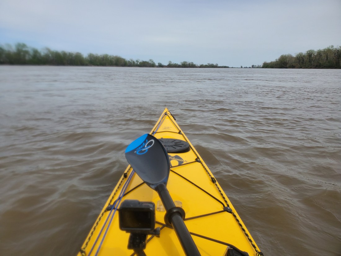
After some necessary trip prep this morning, I took the opportunity to get out on the Missouri River for the first time in 2019. A sunny day in the 60s was too good to pass up. I headed up to Sioux Passage Park in deep North St. Louis County. As I approached the parking lot and boat ramp, it was evident all of this was recently underwater, but they did a great job of plowing the mud and making the facilities usable.
The river was still pretty high. There were a few fishermen around and a couple guys metal detecting in a large pile of flood deposited detritus. I wonder what they expect to find. I dropped my boat at the ramp then parked the car and geared up. My objective for today was threefold: to get an idea of what the swollen Missouri River might feel like for me this summer, to test out my technology setup (more on this in an upcoming post), and working out my paddling muscles along with starting to develop hand callouses in the right places.
I put in at the muddy boat ramp, luckily didn’t really sink into the mud and even managed to get in the boat without getting my legs or feet wet. My goal was to paddle up the side channel that separates Pelican Island from mainland St. Louis County, then once in the main channel of the river, paddle with the current around the curvy backside of the island back to the boat ramp. About 10 miles total.
Pelican Island, St. Louis County, MO
After dealing with some tricky current where the side channel enters the main channel, I was on my way. I quickly realized this was going to be more physical than I had envisioned. The side channel was moving quite quickly. I was paddling at probably 80 to 90% race pace, and was barley making progress relative to the land. At a couple points, I paused to grab water or to change my music selection and started drifting backwards with the current as soon as the paddling stopped. I find it absolutely insane that better people than I have paddled the entire length of this river upstream! Unreal.
Can you tell where I went from paddling upstream to downstream?
A good two hours of hard paddling had me within sight of the end of the island and the main channel. I saw a barge pass by and used the opportunity to check my FindShip app to get the details on the barge. I swung very wide into the main channel to avoid getting pulled back into the side channel from where I just emerged. Immediately I felt more comfortable and relieved to be going with the flow. Surprisingly, it was not very windy way out in the wide-open space of the main channel, pretty shocking considering the weather we’ve been getting lately.
Missouri River, approximate mile marker 15
It took about an hour of relatively leisurely paddling to make my way back to the park boat ramp. As I pulled up, a group of 4 kids wrestled in the thick and creamy mud on the banks while a reluctant mother watched them knowing they were about to wreck the minivan into which they soon piled. I pretty much did the same. With gummy legs, I fell getting out of the yak and managed to muddy myself, the boat and most of my gear. I didn’t mind very much at all, knowing that I’ll be getting a lot more Missouri River mud in my life in short order.
All packed back in the car, I headed to the top-secret workshop of Timber Longboard Co. where I met with Shane and took a look at the progress on the cedar craft that will propel me down the river. I am delighted with the boat so far and look forward to sharing the finished product as it nears completion.
Saddle time in a boat on the river is a critical part of the preparation for this trip. Not only testing gear, fine-tuning the paddle stroke, monitoring physical needs, but all the time to think about additional gear I might consider, or ideas about storage of gear, logistics and plans. With little to no distractions on the river, my mind is left to wander about what is to come shortly as I embark on this adventure.
Late last year, when the concept of my trip was slowly coming to fruition, Sara asked me if I was going to dehydrate food. I really hadn’t thought about it up until that point. I kind of just thought I’d wing it, buy some instant rice meals, packets of tuna and chicken, trail mix and jerky supplemented by grocery or convenience store stops along the way. It was around that time where she ordered a book that was going to fundamentally and nutritionally change my summer.
Shortly after the book arrived, we started looking at food dehydrators. It helped that Sara (and now me) is a regular visitor to the r/trailmeals subreddit. We opted to not go all in and start with the Cadillac of Food Dehydrators, but something a but more economical and entry-level, the Honda Civic of dehydrators – the Nesco 5-tray Snackmaster Pro. (The only downside to this particular dehydrator is a lack of a timer, initially meaning I had to get up in the middle of the night to turn it off. Never fear, technology is here: I picked up a cheap smart outlet than can be controlled from your phone or turned on/off via timer.)
Shortly after the new year, the dehydrator arrived, and I went ahead and tried it out in earnest the first few days. I started with a few easy things, kiwi and potatoes. The kiwis were amazingly delicious, sweet as candy. The potatoes, super thinly sliced were a pretty good snack but not spectacular. Then I went all in and did jerky. I picked up some high quality, Eye of Round and then some 90% lean ground beef. Over the course of a weekend, I followed the recipes in my book to prep, spice and marinate the meat. While I didn’t have a true jerky kit, I improvised my way through it. The results were fantastic, especially the ground beef jerky.
I was hooked. I quickly moved on to more adventurous things: plantains (not good), broccoli (great rehydrated), beans, canned chicken, jasmine rice and pasta. Next was the leather. Thicker liquids can generally be dehydrated then rehydrated at camp with good results. First came pasta sauce, then blended blackberries, bananas with raspberry and bananas with blueberry. The result is indeed a leathery sheet that can be torn and divided to make single serving snacks like a fruit roll-up or rehydrated and added to oatmeal for a tasty breakfast. Then I went back to some whole fruits: blueberries, strawberries, banana, apricots, mango and…pineapples. Probably my favorite item so far, I slap 5 cans of slices pineapple to fill the dehydrator to the max, 12 hours later there’s a chewy delicious snack.
I started assembling meals with 3 or 4 ingredients. Usually it was a protein like chicken, ham, ground beef or tofu, then either rice or pasta, with a veggie like broccoli or edamame.
Of course, with all the food coming out of the dehydrator, I needed to be able to preserve the meals for longer term storage. We went ahead and sprung for a NutriChef vacuum sealer. As the meals and snacks started piling up, I began packaging, sealing, labeling then into the deep freeze for longer term storage. Freezing the items isn’t totally necessary but will extend shelf life a few months. Almost nonstop since the new year, I’ve had something in the dehydrator and my new hobby has turned into a bit of an addiction.
This week I’ll be packaging up what will likely be my last meals for the trip – roast turkey, brown rice and edamame. I have almost 70 total meals. I anticipate this being enough for a 100+ day trip as I’ll also be buying fresher groceries and eating real meals along the way. Jerky and fruit will be my snacks or breakfasts. I’ll likely carry 2 to 3 weeks’ worth of meals at a time, then ship boxes along the way with another 2 to 3 weeks’ worth.
I’m happy I listened to my wonderfully thoughtful wife to pursue food dehydrating. The summer will absolutely mean much more nutritious and delicious food options as I watch the spectacular sunsets along the river over the Great Plains.
(I have quite a few photos of the results on my Instagram feed – link over on the right.)
I’ve gotten so many questions lately about the trip. It’s fantastic that people are taking an interest. I realize I’ve shared some details of the trip but haven’t really provided a real step by step narrative of what I’ll be doing. Here I’ll try my best to provide the overview.
***Disclaimer: the following details are certainly my best guess as to how things will progress based on my planning and from what I have learned from others who’ve undertaken this journey. I’ve tried to make this as accurate as possible, knowing full well I may have some of my facts wrong on a few minor details here. That being said…
Starting around May 4th, I’ll begin packing all the items I’ve been gathering for my trip for transport to Montana. I will pack up my Subaru with everything I will need during the trip as well as food for about the first 2 or 3 weeks at least. The boat goes on top, strapped down securely for the 1,400-mile drive. I plan to leave St. Louis on Thursday, May 9th and driving to Bozeman Airport, where I will pick up Sara who is flying in on Saturday. We’ll then head to Wise River, MT where we’ll stay at a friend’s mountain cottage for a night or two.
Madison River
Sara will drop me and send me on my way down the river somewhere outside West Yellowstone, MT, on the edge of Yellowstone National Park. From there she’ll take off for the long drive back to St. Louis. This is the Madison River, one the three major rivers that forms the Missouri 100 miles downstream. For the first 100 miles on the Madison River, I will encounter 2 large lakes, several stretches of class III – V rapids which I will portage around, and world-famous fly-fishing territory. Descent of the Madison to the start of the Missouri River in Three Forks should take 6 to 7 days. There are established campsites along the way, so I’ll either stay at those, or set up camp at other public areas along the river.
Once I reach Three Forks, MT, I’ll likely stay for a night at the Missouri Headwaters State Park, where the Jefferson, Madison and Gallatin Rivers come together to form the Missouri. I will likely try to coordinate a meetup at that point with a few Montana-based veterans of the MO River descent, picking up some good advice and stories.
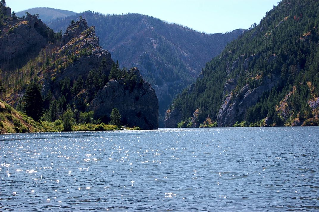
For the next two weeks or so, I’ll be paddling the very upper stretches of the river through dramatic mountain valleys, flat agricultural lands, expansive and wind-swept lakes and meandering curves in the river with the goal of getting to the first significant town along the way – Great Falls, MT. On this stretch, there are a handful of dams that I will have to portage around. Some will be short enough to load my boat and gear onto my two-wheel kayak cart and pull it downstream to the put in. Others may require a longer distance portage, loading my boat and gear onto the vehicle of an obliging river angel to have them shuttle me down. There are campsites here and there, but likely I’ll be scouting out spots along the side of the river that offer some shelter, comfort or facilities for the basics. There is one pretty large lake on this stretch, Canyon Ferry Lake, that is notorious for being very windy and in turn, very choppy. I must be prepared to exercise much caution on when it’s safe to proceed, and when to pull off and wait until calmer conditions prevail. The water in this stretch will likely be very cold still – recent melting of snow and ice will ensure that. It’s still too early to tell if river levels will be at or above average, time will tell.
Canyon Ferry Lake, MontanaGates of the Mountains, Montana
Great Falls is a pretty large town, with all the facilities and amenities that come along with it. I’ll probably rest for a day or two, get a good night sleep in a proper bed, get a few good meals, buy more supplies, and pick up a box of dehydrated meals I will have shipped ahead to supply me for the next couple weeks. I’ll talk to a few local outfitters who run trips on this stretch of the river to get intelligence and advice for what I can expect to encounter. There are 5 significant dams and some stretches of potentially dangerous white water just downstream from Great Falls, so I will arrange a portage around the dams, either by paying an outfitter to shuttle me and my boat, or possibly enlisting friends of friends or river angels to help me along.
After Great Falls, it’s a relatively short stretch to Fort Benton. After Fort Benton, I’ll quickly enter the Upper Missouri River Breaks National Monument. This stretch of about 150 miles was designated as a National Monument in 2001 and will likely be the most beautiful and natural section of river during the entire trip. There are spectacular mountains, walls, overlooks, table tops and valleys that surround the river in this stretch. It’s very popular for floaters and paddlers and I’ll likely encounter the most traffic here.
Upper Missouri River Breaks National Monument, Montana
Passing through Upper Missouri River Breaks, I will quickly enter the first of three very large reservoirs – Fort Peck Lake. The three major lakes, Fort Peck, Sakakawea and Oahe were formed when the Army Corps of Engineers was tasked with building massive dams from the late 40s, completed in the early 50s, to generate power and help with flood control and irrigation along the river. The dams at the end of each of these lakes, as well as Gavins Point dam further downstream, have a huge effect on the flow along entire length of the Missouri River, as well as any person or entity who has any kind of connection to the river. All of the recent (and past) flooding issues circle back to the Army Corps’ management of river flows via these dams. There are endless debates and controversies around river management that all tie back to these structures, and I am eager to learn more firsthand.
The first difficult aspect of these large lakes is actually getting into them. Where the flowing river dumps into the massive pool of stagnant water, there are many braided channels that are constantly changing. What I see on Google maps (or any other map I have) may be totally outdated and inaccurate. I may be paddling in what looks like a main channel, only to suddenly run into sloppy mud and with much difficulty, have to navigate, sometimes walking in hip deep mud, back into open water.
Braided channels entering Fort Peck Lake, Montana
The second major consideration and potential danger on these large lakes is weather conditions. Wide open spaces with little to no natural wind breaks mean more often than not, conditions on the water are less than ideal. Even a light wind can lead to large waves when the lake is 1 or 2 miles wide. Keeping control of your boat and being able to paddle where you are planning to becomes a tiring exercise. Navigation-wise, there are many large coves and fjords that look and feel like they are the continuation of the main branch of the lake. Unless you keep a close eye on your maps and navigation tools, you can easily get off track and on a lengthy and costly detour. And finally, not being able to see for a long distance over hills and mountains means storms can approach very quickly. Being stuck 1 or 2 miles away from land or shelter when a massive upper midwestern thunderstorm blows up is a dangerous proposition. I am fully expecting that due to weather, I will be shore bound for potentially days at a time waiting for conditions to improve.
Fort Peck Lake is 134 miles long. Covering that amount of distance in non-moving water, in potentially rough conditions will take a while. Fort Peck is located at the end of Fort Peck Lake, I’ll portage around the dam there then gladly get back into to flowing water. From Fort Peck to the eastern edge of Montana and the border with North Dakota, the river meanders and makes its way through various Native American reservation land. I will have to remain aware of where it’s permissible to stop and camp and where it is not.
Crossing into the second state on the journey, North Dakota, I will quickly enter another massive reservoir/lake – Lake Sakakawea. I’ll encounter all of the same conditions and dangers on this lake, and it is 177 miles long. I’ve been in touch with the owner of a lovely resort in this lake at Tobacco Gardens. I imagine I’ll stop to refresh and recharge for a few nights there.
Garrison Dam, Lake Sakakawea, North Dakota
After Lake Sakakawea, it’s back into moving water for a relatively short stretch which will get me all the way to Bismarck, ND. I’ll likely use this as another chance to get a good night’s bed rest, a shower, a couple square meals and some shopping for necessities, and possibly a food resupply. Because shortly after Bismarck, it’s back into yet another lake – Lake Oahe which checks in at an unbelievable 231 miles in length. It’s the longest of the three major lakes. On the upper end of Lake Oahe is the site of the protests over the Dakota Access Pipeline in recent years. Many of the lands around Lake Oahe are also Native American lands, hence the need to plan out where it is permissible to pull off and camp.
Completing Lake Oahe will take multiple weeks and will push me to my physical and mental limits, I am certain. Once completed, however, I will have crossed from North to South Dakota and will be done with the three major Missouri River reservoirs. Unfortunately, the next few hundred miles is also mostly on lakes – Lake Sharpe, Lake Francis Case and Lewis and Clark Lake. Though not as wide or difficult as the three big boys, these will still be challenging, nonetheless. I’ll get to consider doing fun things, like cutting off 20 miles of paddling by portaging my boat and gear up and over a narrow ridge at a huge bend in the lake.
The big bend on Lake Sharpe, South Dakota
At Yankton, SD, the Missouri River reverts back to a free flowing, undammed and hopefully quicker mode of transport. Unfortunately, much of the flooding that’s taken place this year has occurred near Yankton, which is where Gavins Point Dam is located, or further downstream into Nebraska, Iowa and Missouri. One major challenge I may face is the aftermath of the calamitous flooding that’s already occurred or will continue to into the Spring and Summer of this year. Time will tell if this stretch of the river will continue to be at flood stage by the time I get there. Even if it is not, I am certain I will experience its after-effects, including more trash and debris in and around the river, riverside sites and campgrounds no longer open or accessible, sloppy mud everywhere and a general lack of facilities. And a recent headline mentioned flood induced raw sewage pouring into the river at Omaha for possibly months to come, so I got that goin’ for me.
Gavins Point Dam, South Dakota
The Missouri River forms the border between South Dakota and Nebraska, then Nebraska and Iowa further down. I will pass through Sioux City, IA and Omaha, NE before finally seeing my home state of Missouri coming up on my left. I’ll pass through Atchison, KS, where my parents first met at Benedictine College. Kansas City will represent a major milestone, as everything downstream of there are waters I am pretty familiar with as a MR340 veteran. From Kansas City, I hope to take a leisurely 7 to 10 days to make my way back home. The final stretch, from St. Charles, MO, through the confluence with the Mississippi, over the Chain of Rocks and finishing at the Arch, I hope to paddle with as many of my paddle buddies who are willing to finish off the trip with me.