I’ve gotten so many questions lately about the trip. It’s fantastic that people are taking an interest. I realize I’ve shared some details of the trip but haven’t really provided a real step by step narrative of what I’ll be doing. Here I’ll try my best to provide the overview.
***Disclaimer: the following details are certainly my best guess as to how things will progress based on my planning and from what I have learned from others who’ve undertaken this journey. I’ve tried to make this as accurate as possible, knowing full well I may have some of my facts wrong on a few minor details here. That being said…
Starting around May 4th, I’ll begin packing all the items I’ve been gathering for my trip for transport to Montana. I will pack up my Subaru with everything I will need during the trip as well as food for about the first 2 or 3 weeks at least. The boat goes on top, strapped down securely for the 1,400-mile drive. I plan to leave St. Louis on Thursday, May 9th and driving to Bozeman Airport, where I will pick up Sara who is flying in on Saturday. We’ll then head to Wise River, MT where we’ll stay at a friend’s mountain cottage for a night or two.

Sara will drop me and send me on my way down the river somewhere outside West Yellowstone, MT, on the edge of Yellowstone National Park. From there she’ll take off for the long drive back to St. Louis. This is the Madison River, one the three major rivers that forms the Missouri 100 miles downstream. For the first 100 miles on the Madison River, I will encounter 2 large lakes, several stretches of class III – V rapids which I will portage around, and world-famous fly-fishing territory. Descent of the Madison to the start of the Missouri River in Three Forks should take 6 to 7 days. There are established campsites along the way, so I’ll either stay at those, or set up camp at other public areas along the river.
Once I reach Three Forks, MT, I’ll likely stay for a night at the Missouri Headwaters State Park, where the Jefferson, Madison and Gallatin Rivers come together to form the Missouri. I will likely try to coordinate a meetup at that point with a few Montana-based veterans of the MO River descent, picking up some good advice and stories.
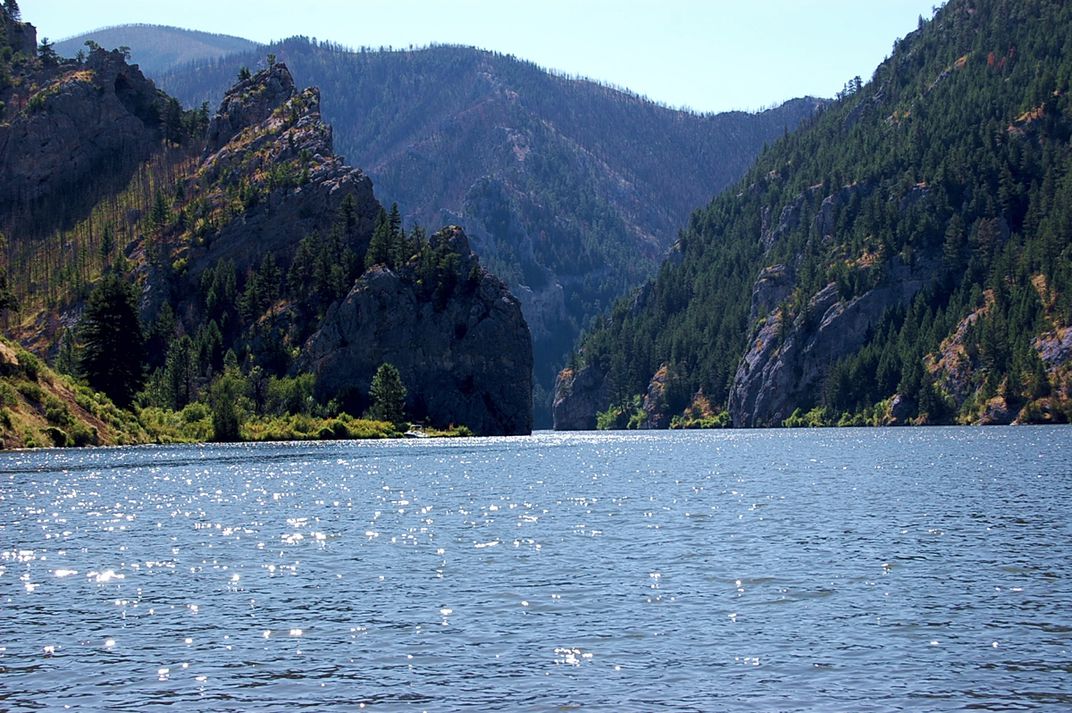
For the next two weeks or so, I’ll be paddling the very upper stretches of the river through dramatic mountain valleys, flat agricultural lands, expansive and wind-swept lakes and meandering curves in the river with the goal of getting to the first significant town along the way – Great Falls, MT. On this stretch, there are a handful of dams that I will have to portage around. Some will be short enough to load my boat and gear onto my two-wheel kayak cart and pull it downstream to the put in. Others may require a longer distance portage, loading my boat and gear onto the vehicle of an obliging river angel to have them shuttle me down. There are campsites here and there, but likely I’ll be scouting out spots along the side of the river that offer some shelter, comfort or facilities for the basics. There is one pretty large lake on this stretch, Canyon Ferry Lake, that is notorious for being very windy and in turn, very choppy. I must be prepared to exercise much caution on when it’s safe to proceed, and when to pull off and wait until calmer conditions prevail. The water in this stretch will likely be very cold still – recent melting of snow and ice will ensure that. It’s still too early to tell if river levels will be at or above average, time will tell.

Great Falls is a pretty large town, with all the facilities and amenities that come along with it. I’ll probably rest for a day or two, get a good night sleep in a proper bed, get a few good meals, buy more supplies, and pick up a box of dehydrated meals I will have shipped ahead to supply me for the next couple weeks. I’ll talk to a few local outfitters who run trips on this stretch of the river to get intelligence and advice for what I can expect to encounter. There are 5 significant dams and some stretches of potentially dangerous white water just downstream from Great Falls, so I will arrange a portage around the dams, either by paying an outfitter to shuttle me and my boat, or possibly enlisting friends of friends or river angels to help me along.
After Great Falls, it’s a relatively short stretch to Fort Benton. After Fort Benton, I’ll quickly enter the Upper Missouri River Breaks National Monument. This stretch of about 150 miles was designated as a National Monument in 2001 and will likely be the most beautiful and natural section of river during the entire trip. There are spectacular mountains, walls, overlooks, table tops and valleys that surround the river in this stretch. It’s very popular for floaters and paddlers and I’ll likely encounter the most traffic here.

Passing through Upper Missouri River Breaks, I will quickly enter the first of three very large reservoirs – Fort Peck Lake. The three major lakes, Fort Peck, Sakakawea and Oahe were formed when the Army Corps of Engineers was tasked with building massive dams from the late 40s, completed in the early 50s, to generate power and help with flood control and irrigation along the river. The dams at the end of each of these lakes, as well as Gavins Point dam further downstream, have a huge effect on the flow along entire length of the Missouri River, as well as any person or entity who has any kind of connection to the river. All of the recent (and past) flooding issues circle back to the Army Corps’ management of river flows via these dams. There are endless debates and controversies around river management that all tie back to these structures, and I am eager to learn more firsthand.
The first difficult aspect of these large lakes is actually getting into them. Where the flowing river dumps into the massive pool of stagnant water, there are many braided channels that are constantly changing. What I see on Google maps (or any other map I have) may be totally outdated and inaccurate. I may be paddling in what looks like a main channel, only to suddenly run into sloppy mud and with much difficulty, have to navigate, sometimes walking in hip deep mud, back into open water.

The second major consideration and potential danger on these large lakes is weather conditions. Wide open spaces with little to no natural wind breaks mean more often than not, conditions on the water are less than ideal. Even a light wind can lead to large waves when the lake is 1 or 2 miles wide. Keeping control of your boat and being able to paddle where you are planning to becomes a tiring exercise. Navigation-wise, there are many large coves and fjords that look and feel like they are the continuation of the main branch of the lake. Unless you keep a close eye on your maps and navigation tools, you can easily get off track and on a lengthy and costly detour. And finally, not being able to see for a long distance over hills and mountains means storms can approach very quickly. Being stuck 1 or 2 miles away from land or shelter when a massive upper midwestern thunderstorm blows up is a dangerous proposition. I am fully expecting that due to weather, I will be shore bound for potentially days at a time waiting for conditions to improve.
Fort Peck Lake is 134 miles long. Covering that amount of distance in non-moving water, in potentially rough conditions will take a while. Fort Peck is located at the end of Fort Peck Lake, I’ll portage around the dam there then gladly get back into to flowing water. From Fort Peck to the eastern edge of Montana and the border with North Dakota, the river meanders and makes its way through various Native American reservation land. I will have to remain aware of where it’s permissible to stop and camp and where it is not.
Crossing into the second state on the journey, North Dakota, I will quickly enter another massive reservoir/lake – Lake Sakakawea. I’ll encounter all of the same conditions and dangers on this lake, and it is 177 miles long. I’ve been in touch with the owner of a lovely resort in this lake at Tobacco Gardens. I imagine I’ll stop to refresh and recharge for a few nights there.

After Lake Sakakawea, it’s back into moving water for a relatively short stretch which will get me all the way to Bismarck, ND. I’ll likely use this as another chance to get a good night’s bed rest, a shower, a couple square meals and some shopping for necessities, and possibly a food resupply. Because shortly after Bismarck, it’s back into yet another lake – Lake Oahe which checks in at an unbelievable 231 miles in length. It’s the longest of the three major lakes. On the upper end of Lake Oahe is the site of the protests over the Dakota Access Pipeline in recent years. Many of the lands around Lake Oahe are also Native American lands, hence the need to plan out where it is permissible to pull off and camp.
Completing Lake Oahe will take multiple weeks and will push me to my physical and mental limits, I am certain. Once completed, however, I will have crossed from North to South Dakota and will be done with the three major Missouri River reservoirs. Unfortunately, the next few hundred miles is also mostly on lakes – Lake Sharpe, Lake Francis Case and Lewis and Clark Lake. Though not as wide or difficult as the three big boys, these will still be challenging, nonetheless. I’ll get to consider doing fun things, like cutting off 20 miles of paddling by portaging my boat and gear up and over a narrow ridge at a huge bend in the lake.

At Yankton, SD, the Missouri River reverts back to a free flowing, undammed and hopefully quicker mode of transport. Unfortunately, much of the flooding that’s taken place this year has occurred near Yankton, which is where Gavins Point Dam is located, or further downstream into Nebraska, Iowa and Missouri. One major challenge I may face is the aftermath of the calamitous flooding that’s already occurred or will continue to into the Spring and Summer of this year. Time will tell if this stretch of the river will continue to be at flood stage by the time I get there. Even if it is not, I am certain I will experience its after-effects, including more trash and debris in and around the river, riverside sites and campgrounds no longer open or accessible, sloppy mud everywhere and a general lack of facilities. And a recent headline mentioned flood induced raw sewage pouring into the river at Omaha for possibly months to come, so I got that goin’ for me.

The Missouri River forms the border between South Dakota and Nebraska, then Nebraska and Iowa further down. I will pass through Sioux City, IA and Omaha, NE before finally seeing my home state of Missouri coming up on my left. I’ll pass through Atchison, KS, where my parents first met at Benedictine College. Kansas City will represent a major milestone, as everything downstream of there are waters I am pretty familiar with as a MR340 veteran. From Kansas City, I hope to take a leisurely 7 to 10 days to make my way back home. The final stretch, from St. Charles, MO, through the confluence with the Mississippi, over the Chain of Rocks and finishing at the Arch, I hope to paddle with as many of my paddle buddies who are willing to finish off the trip with me.
Piece of cake.
mf
