Resources Used, Resources Abused

As I finished paddling Montana and entered North Dakota, I noticed very obvious and sometimes instrusive signs of the use of two naturally occuring resources. This post is not (entirely) an opinion piece. I have an obvious bias as an outdoorsman, and aspiring Boatman, and an armchair environmentalist, but I am also a life-long resident of large cities and recognize the importance and need for large-scale farming and gas/oil production. For better or for worse, I consume food products farmed all over the world, and I fill my car with gas so I can drive the 30 minutes to work every day (when I’m not paddling 8 to 10 hours a day, of course). I’m merely trying to educate and show what the impact of these industries is on this quiet but otherwise pristine stretch of the Missouri River.


First, the use of river water for irrigation purposes. From Fort Peck Dam through the border of Montana/North Dakota, I saw dozens of these along the river:

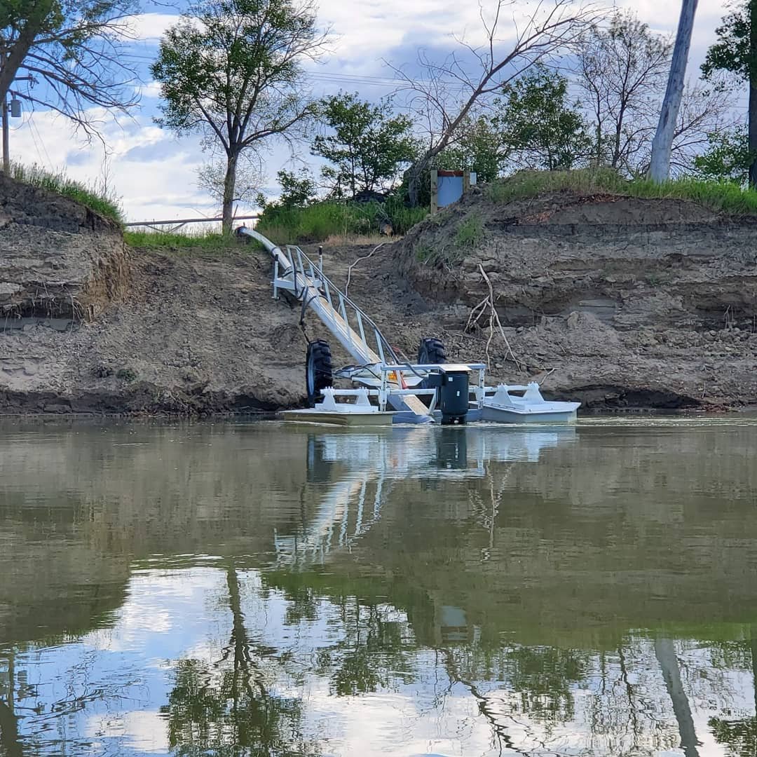
I thought they might have a more technical or industrial name, but when I slowed to talk to a guy who was working on one, he told me they were floating water pumps, obvious enough. Basically, it’s a big tube that pumps water from the river to farmland that otherwise wouldn’t get enough water to support crops. Usually they are hooked up to either a noisy generator or power lines that have been run to the river’s edge to power the movement of the water. When looking for places to camp along the river, I avoided these pumps, as the noise from the generators was loud and didn’t quite provide the ambient sound I desired when I was trying to relax, watch a great sunset or sleep at night.

I also had the fortunate experience to talk to a gentlemen after the 5k run at the Fort Union Rendezvous who worked in the agriculture industry, though wasn’t a farmer himself. I quizzed him on the use of these pumps, so ubiquitous along this stretch. He explained that these were indeed used for irrigation of farm fields. The primary crops grown in Northeastern Montana are corn and…a surpise to me, sugarcane. I’m not an expert by any means, but he confirmed a thought I had that typically sugarcane is a fairly water-intensive crop. I usually think of big sugarcane plantations on islands or along coasts of Caribbean nations. He further explained that typically annual rainfall here is 10 inches, and these types of crops grown here require at least 30. So the shortfall is pumped from the river. Another somewhat alarming fact he told me, was that there is little (i.e. none) regulation as to how many pumps are put into the river and how much water they pump out. If you own land on the river, you can pump as much water as you’d like out of the river.

2019, as all of us have unfortunately seen, has been a historically high water year. From the still snow packed mountains of the Rockies in Montana, to the water-logged prairies of the Dakotas, to the failed dams of Nebraska, to the busted levees and sandbagged main streets of towns up and down the river, there is no shortage of water this year. And most years, the Missouri holds so much water that a few pumps in Montana are but a drop in the literal ocean of river water. And my agricultural industry buddy confirmed the same. There is no thought to the impact of water levels from the irrigation here. But my thought immediately went to the Colorado River. The countless articles, maybe a documentary here or there, explaining that due to overuse and abuse of the water resources of the Colorado River, it no longer even reaches the Sea of Cortez; it runs dry far before that. I am by no means advocating for limiting the use of Missouri River water to irrigate farmland and provide much needed food and resources. I am simply remarking at what seems like a fairly slippery slope of unregulated water usage on the Missouri River, or pretty much any body of water.


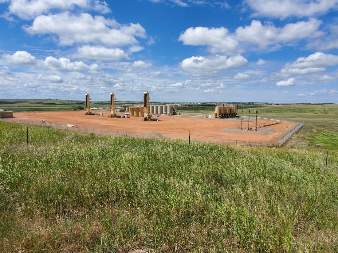
Almost immediately upon crossing the eastern border of Montana into North Dakota, I was warmly greeted by this sight:

Then I began seeing the bright flares of something – I assumed the oil or gas, being burned at the site of the pumps or wells. Like this one at the very upstream end of Lake Sakakawea:

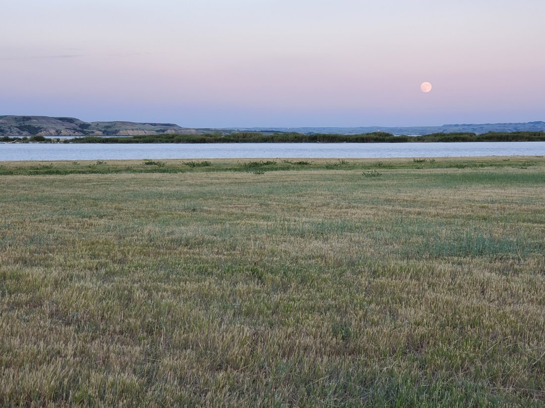
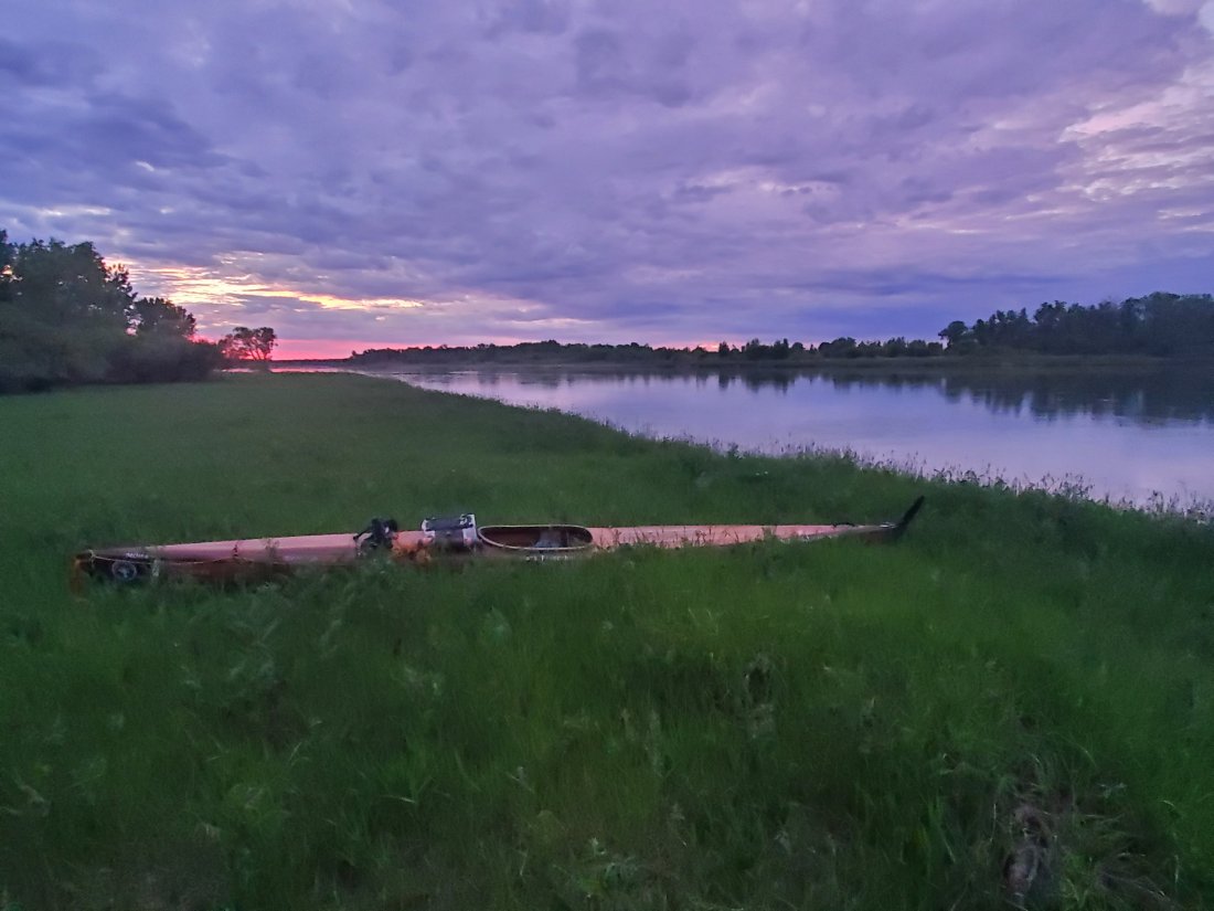
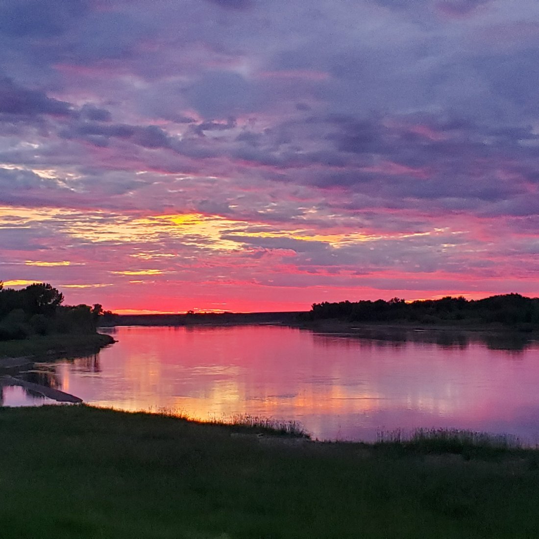
At an amazing spot near Williston, ND, I camped at the edge of the river one evening and enjoyed a full moon coming over the horizon. I was on the phone with my wife and remarked to her how beautiful it was, and how from the door of my tent, I could also count about 8 gas flares in the surrounding hills (if you look closely, they are there):

Again through articles I’ve read, documentaries here and there, I was aware of the oil and fracking industry and how prevalent it is in North Dakota. However, witnessing it in person was bit of a shock at first. As I paddled the first few dozen miles of Lake Sakakawea, I would turn a corner on the lake, see three or four more flares in the distant hills, and joke to myself the Eye of Sauron was still watching me. I was paddling about 50 yards from shore, heard what I though was thunder on a cloudless day, but it was more sustained. I felt actual vibrations coming from the water, through my wooden kayak and into my posterior. I paddled around the next decline in the bluff and saw a massive pumping station or oil well a quarter mile from me. I pulled into the cove of Tobacco Gardens late on a Monday afternoon and noted its peaceful and beautiful surroundings, then once I got on shore, counted 5 active oil sites with flares surrounding it. For the next two days at Tobacco Gardens, I heard the rumble of large trucks coming to pick up the oil on the road behind my cabin. When the sun went down, after I enjoyed the spectacular sunset, I witnessed another show in the sky – only this one went on all night:

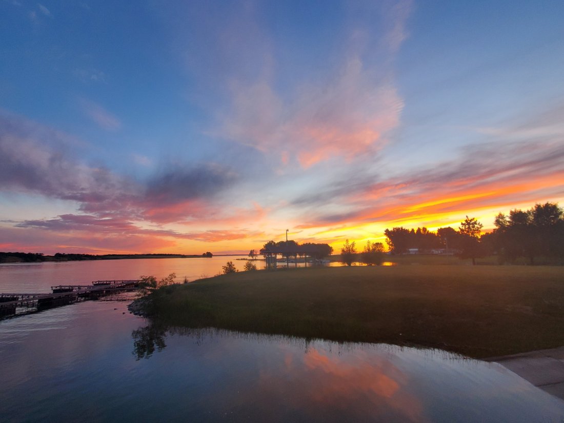
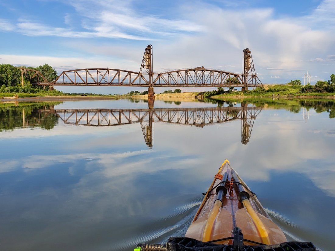
When my friend Dan and I were camped at Four Bears further down the river, we enjoyed some beverages into the late evening hours, then walked to the edge of the peninsula to see this:

At Tobacco Gardens, I had the pleasure of joining the owner Peggy’s daughter Jade and son-in-law Levi for Jade’s birthday dinner. Both Jade and Levi work in the oil industry so I got to ask them some pretty good questions and get their perspective. Obviously, the oil industry and oil boom in North Dakota in the past 10 to 15 years has led to unprecedented growth in the population, income and overall economic strength of the state’s economy and its residents. A lot of Peggy’s business comes from those who are in the area due to working in the industry. Having a well-paying job in the industry allows young people to stay in North Dakota, or incentivizes others to move to North Dakota as well as lead pretty good quality lives. As we rode the wagon train into Watford City, I remarked at the brand new apartment complexes, condos and subdivisions of new homes that wouldn’t look out of place in the growing cities I’ve spent time in – Nashville, Chicago, St. Louis (uh, yeah sure, St. Louis). Peggy confirmed much of the development of tiny Watford City was not there 10 years ago.

A couple other facts I was pretty shocked to learn: the light pollution caused by the flares at night in this region of North Dakota exceeds the light produced by the metropolitan area of Minneapolis! The flares that are burning off gas or oil are mandated by law to only burn 2% of excess oil produced. That means that theoretically, 98% of the oil and gas is captured, the flares represent only the 2% that has to be burned as excess because storage is full until the next truck arrives to move out the inventory. (Some stations are connected to pipelines that spiderweb the state, I witnessed a few pipelines being built.) That’s fairly shocking, because flares were everywhere! They must be producing massive amounts of gas if what I saw being burned off was only 2%. I can’t even begin to imagine the impact the industry here has on climate change, and frankly I’m a bit nautious when I think about it…

I was also fortunate enough to have time to speak to Peggy in pretty good detail about her experience with the industry as a life-long resident, a successful land and business owner who I expect would have pretty strong feelings on the topic. I won’t include everything we discussed, but I’d summarize her views as mixed. Many of her kids and kids’ in-laws work in the industry and lead pretty good lives. She has to constantly deal with the industry through everything from her campers sharing the roads with the oil trucks (including her literally chasing down and reporting speeding drivers – where they pretty much get fired if Peggy reports them), the encroachment onto her or friends’ property, and restrictions being put in place by the Army Corp of Engineers, who manages the Lake and works closely with the oil industry. She is well known by those in the industry as someone who won’t bend to their whims and will put up a fight for what she feels is right, and that gives me great comfort and makes me admire her beyond just being a world-class River Angel.

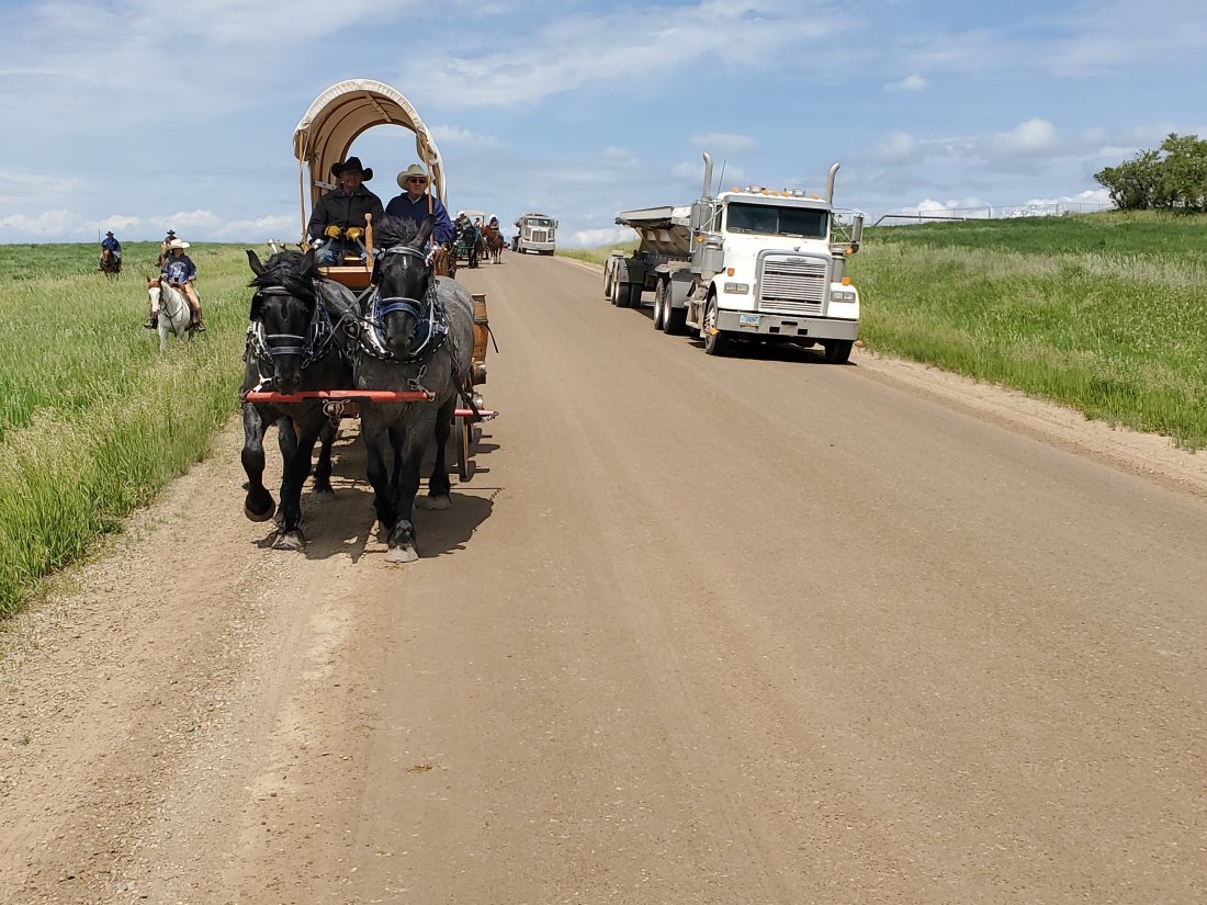
Riding the wagon train from the outskirts of Watford City to the county fairgrounds provided some good opportunities to capture more of the impact of the industry:

Like I said, I am not in a place to make a definitive determination that these things I’ve seen are positive or negative. I think it very safe to state that there are both positives and negatives to the use of river water for irrigation as well as the mining of minerals and resources from the Earth. We could debate endlessly on which may outweigh the other, but I have many more miles to paddle, more things to learn and endless more experiences to encounter.

Thanks for reading.

mf

P.S. – Within the next week, I will paddle through the upper end of Lake Oahe, where many of you will remember is where the intense and sometimes violent protests of the Dakota Access Pipeline (DAPL) took place within the past couple years. It’s my intent to see where it happened, witness the impact of the pipeline construction or aftermath and hopefully speak to people that were involved or somehow affected by it.

Revised Itinerary

Apparently, I’ve been doing some paddling. As I look at my original estimated itinerary, I am nearly 1 month ahead of what I had planned. Granted, my original schedule was conservative and based on not a lot of on the water experience or adjustments for better-than-expected weather or high and fast water as well as just what I’d fall into mileage-wise as a daily routine.

I appreciate everyone who’s checked in with me on the inter-webs and would even consider coming out to meet me at some point on my journey. I was super excited to see my friend Dan for a couple days in northwest North Dakota and am looking forward to seeing my cousin David tomorrow when he flies into Bismarck to support me for a few days. Anyone else entertaining the idea of making the trip to anywhere along the river between Garrison, ND and St. Louis, I am honored you’d consider making the journey! Below is my best estimate for when I will be where. Same disclaimers as before: subject to weather, my bodily health, river/flood conditions and acts of God. But here is my best guess. Reach out to me if you want to talk about any specific plans!!!

Garrison Dam to Bismarck, ND: 6/29 – 6/30

Bismarck to Oahe Dam/Pierre, SD: 7/1 – 7/16

Oahe Dam/Pierre, SD to Big Bend Dam: 7/18 – 7/22

Big Bend Dam to Fort Randall Dam: 7/23 – 7/27

Fort Randall Dam to Sioux City, IA: 7/29 – 8/2

Sioux City, IA to Omaha, NE: 8/3 – 8/5

Omaha, NE to Kansas City, MO: 8/6 – 8/12

Kansas City, MO to St. Louis, MO: 8/14 – 8/20

mf

Lake Sakakawea

I pulled into the marina at Lake Sakakawea State Park yesterday around 3pm, completing my paddle across the largest reservoir by volume in the United States. In many respects, this has been the most challenging portion of the trip so far. The weather and lake conditions presented some pretty big obstacles both on and off the water. However, I receieved some of the finest and most kind and generous hospitality of my trip along the lake.

In talking with friends and family, I realize Lake Sakakawea might be the most obscure and least known large body of water in the country. So before the story of my crossing of the lake, a few facts, figures and other tidbits about the Lake I learned before and during my trip. Lake Sakakawea was formed when the Garrison Dam was completed in 1953. It’s contruction created a 180 mile long reservoir, starting around Williston, ND. Sakakawea is the traditional/authentic derivation of Sacajawea, the name of the Indian woman on Lewis and Clark’s 1804 – 1806 expedition. A large portion of the land flooded as the Missouri River began to fill the reservoir was a part of the Fort Berthold Reservation, the traditional area inhabited for over a millennium by the three affiliated tribes of the Mandan, Hidatsa and Arikara. 25% of the reservation was literally liquidated under the lake – about 155,000 acres of their richest and most productive crop and grazing lands. Additionally, 1,700 members of the tribes, or 80% of the population, was forced to relocate to towns nearby, or not nearby at all. In many tribal leaders’ eyes, this essentially decimated the three tribes tradtional homeland and community forever. The photo of the signing of the bill to create the dam shows tribal chairman George Gillette weeping. I saw this photo when I was checking out the sites in what is today the tribal heart of Fort Berthold – Four Bears/New Town. It’s a heartbreaking photo:

Not to get too caught up in current events or hot-button issues, I can’t help but think the way our country has treated ‘others’ in the past was ugly, abusive, reprehensible. We recoil in shock at the injustices that occured in our nation’s history, and I’ve been fortunate enough to learn about these events firsthand on this trip. And while I am by no means up to date on current events, especially what’s happening at our Southern border, I catch tidbits here and there. It seems the horrors continue today, uninterrupted from the ugly ways of our past. I can’t help but share George Gillette’s feelings of resignation and hopelessness, but also the will to fight for justice for people of all colors or nationalities.

Paddling the Lake

My Sakakawea journey began as I passed under the Williston, ND bridge Sunday afternoon, June 16th. About 15 miles before that, the longest undammed river in the US at 500+ miles, the Yellowstone River, converges with the Missouri, pouring in the chocolate colored sediment and lots of driftwood, and roughly doubling the width of the river. I made it about 10 more miles past Williston to a great campsite at an American Legion park. The next morning, the weather was almost perfect and I made the 27 miles to the resort at Tobacco Gardens. After a lovely 2 days of relaxation and fun mentioned in my previous post, I got back on the river and paddled on another very nice day the 31 miles into Four Bears, ND. My friend Dan and I camped that night at a colorful and lively campground, mostly occupied by Native Americans.

I’d planned to depart the next afternoon, but it was a chilly and windy day, with afternoon showers that seemed to come sideways, rendering our upgraded campsite with small pavilion useless. Dan took off to get to Omaha as the rain was winding down in the afternoon, I opted to stick around another night and paddle the next day. The forecast for Saturday, the next day, had looked decent. As soon as Dan left, I checked the forecast again. Unbelievably, winds the next day were now projected to be 25 – 30mph all day. Disappointment. Sure enough, the next morning I woke up to a shaking tent, and peeking out of my tent saw large waves on the lake. Ugh. In non-stop winds like that, I find that it’s often exhausting just standing or sitting there with no wind break. I hung out in my tent for a few hours, and it was apparent many in the camp were also staying in. Finally, I bucked up and walked up to the casino to use their wifi and free lobby coffee, then walked over the beautiful Four Bears bridge and up a hill to an amazing overlook above town. They also had a pretty fantastic historical site with signage near one end of the bridge documenting the history of the 3 bridges that have been built there and well as the above-mentioned travesties experienced by the three affiliated tribes throughout their history. Later in the evening, I hit the casino buffet and ate an embarassing amount of food, making up for past and future days where I am burning a lot more calories than I am consuming.

I crossed my fingers for a better day Sunday. It started out windy again, but probably only around 10 to 12 mph. It calmed down throughout the day and I was able to make 25 miles, finding a nice beach campsite around 4pm. I enjoyed a relaxing evening and a gorgeous sunset over the lake. Calm forecast again for the next day, fantastic! In the morning, I set out and made the 180 degree turn at the big bend in the lake – Independence Point. I saw rainclouds passing in front of me, then behind me, but the water remained relatively calm. When I finally made the eastern turn for the long straight stretch that would take me to the end of the lake, I saw storm clouds amassing behind me. I raced in the increasingly rough waves to a cove I’d seen from a distance that might provide some shelter from the storm. For the first 5 minutes I was on shore, I grabbed the essentials for what I’d need to ride out the storm. I pulled my boat pretty far onto the land and grabbed some essentials. As the wind picked up to around 40 then 50, then maybe even some gusts of 60 with sideways rain, I huddled in my camp chair with my umbrella facing the wind, behind a few trees as an additional wind break. The waves kept reaching higher, forcing me to move the boat further up, and my gear from being pulled into the lake.

Eventually the storm passed, the sun came back out and the lake returned to a somewhat normal state. I set up my tent and enjoyed a dehydrated dinner, even as I picked small green caterpillars off my gear and clothes and brushed away dozens of ticks. I’d been lucky, these were the first ticks I’d been exposed to on the trip. I packed up in the morning and paddled around 18 miles to get to the Dakota Waters Resort, where I had more river angels awaiting my arrival. This was a tough day. The wind was only forecast for 8 to 10 mph, which would be no big deal, but wind was actaully in the 15 to 20mph range. Big waves, plus my rudder picked today to start sticking, making me have to pull over at nearly non-existent beach heads to set it right.

I arrived at Dakota Waters in mid-afternoon and met Thomas and Amber, the two young owners/operators of the lovely resort. I got a nice shower, some cold beers, and with their regular off day coinciding with my arrival, was able to spend a lot of the afternoon sharing conversations and drinks on the beautiful deck that Thomas had just finished contruction on overlooking their picturesque cove. They fed me a wonderful dinner of salmon, beans and potatoes. After another legendary Sakakawea sunset from the deck, I joined Thomas, Amber’s younger brother, also Thomas, and some fun local campers for a campfire, s’mores and few late night beers.

The next day, I was fully prepared for another rest day after a rough one the day before, but forecasts of 1 – 3mph winds were too good to pass up. It turned out to be a one in a million day on the water, almost a flat sheet of glass for almost the whole 20 miles to the State Park at Garrison Dam. If it were a weekend day, or god forbid a holiday, the boats speeding in and out of the popular marinas and boating areas near the dam would have been a handful to deal with but a quiet weekday afternoon allowed me safe passage.

I spent 10 total days on Sakakawea – 6 days where I was able to paddle and make miles, 2 days where I willingly rested and enjoyed the wonderful experience of Tobacco Gardens, and 2 days where I was unwillingly stuck onshore at Four Bears. Even with the wind days, I still consider myself extremely lucky to have the weather and water conditions that I’ve had. I dealt with my first on-water storm and rode it out, I dealt with a very rough day of paddling as well as with a minor equipment issue – the rudder which I was able to easily fix once I got to Dakota Waters.

I feel like every day, I continue to learn things. About myself, my abilities, my boat, the lake, the water, my surroundings, the people I interact with, their rich histories and stories, and so much more. I look forward to each and every day, whether I’ll be out on the water paddling until I am sore, or forced to find adventures off the water. Every day has something new and exciting to see and experience. It’s helped that I’ve had pretty decent cell phone reception as well, where I can keep in touch with friends, family and most importantly, my hwife.

On to about 80 miles of river with a current! To Bismarck where pretty quickly I’ll hit my longest lake – Oahe.

mf

The Art of River Angeling, Perfected

Since I made my plans for a 2019 descent of the Missour River public, I saw posts on Facebook from Peggy Hellandsaas at Tobacco Gardens Resort and Marina on Lake Sakakawea in North Dakota. In fact, I believe she might have been among the first few commenters on my original post announcing my trip. Lots of the posts were similar – waiting for you at Tobacco Gardens, can’t wait for your arrival at TG, etc. In my mind, that would be well into my trip so didn’t think much of it. I did communicate with Peggy to have one of my re-supply packages shipped there.

The past few weeks as I got closer, the messages continued, offering encouragement and best wishes. Peggy also ensured my chosen site to camp the night before arriving at TG was ideal – a completely empty American Legion park with water, shelter and a picnic table – a perfect spot compared to the miles of willows and swamps or the flooded and sketchy Williston, ND boat ramp prior to encountering the campground. I set out early from the American Legion park with the intent to paddle the nearly 27 miles to Tobacco Gardens – pretty much the first 27 miles of Lake Sakakawea.

Around 4pm, with about 3 miles left to get to the cove that contained Tobacco Gardens, I saw my first boat of the day. It veered towards me, cut its engines to idle and I heard an ‘Ahoy!’ Surprised, but then again not really, it was Peggy with a few friends and staff of Tobacco Gardens, welcoming me in. They offered to tow me the rest of the way, but I politely declined. Eventually I made the turn into the cove and paddled over to the marina, where I was met by Peggy and grandson Rowdy. She directed me to a spot to park my kayak, about 50ft from the front door of a tiny cabin that was to be my home for as long as I’d like. Rowdy was a huge help unpacking my gear and carrying it up to the cabin. After getting my bearings and changing into some not so funky clothes, I went over to the marina cafe, where Peggy had cold beer and great conversation waiting. We talked about my trip so far and paddlers who had enjoyed hospitality at TG in the past. She showed me a few paddles they had all signed as well as a guest book for more extended messages.

After a much needed quick shower, my first in about a week, I went back to the cafe, where Peggy had me sit with her daughter Jade, son-in-law Levi and their two daughters, where it was actually Jade’s birthday dinner! I was served ribs, salad, mac n cheese, fries, garlic bread and eventually an amazing ice cream dessert. I enjoyed conversation with Jade and Levi, learning quite a bit as they both work in the oil industry. After dinner, Peggy brought out a cooler filled with ice and beer, a pitcher of drinking water, then 3 MORE racks of ribs to eat the next day for lunch, as well as two massive rice krispy treats. I was also invited to raid the convenience store portion of the cafe for absolutely anything I needed. With lack of staff, the TG cafe was closed for food service Tuesday and Wednesday, the next two days I’d be there. With Peggy’s generosity, there was no chance of me going hungry, however. I enjoyed a relaxing evening watching the sunset over the lake from the porch of my cabin.

The next day was reserved for almost nothing but lounging and resting my body and mind. I dropped off some laundry with Peggy mid-morning, the fired up the grill at my cabin to reheat the ribs. Peggy also allowed me to fix up a huge salad to go along with it, as well as a steak for dinner. After that big lunch, naturally I took a nice two hour nap, the first time I’ve gotten to do that during my trip. My re-supply package arrived via UPS on schedule later that afternoon and I spent the evening unpacking and organizing all my gear, talking with my cousin Dave who is making the journey to visit me in a week, monitoring the arrival the next day of another friend, Dan. Peggy also took me and two other campers on a ride on her side-by-side: one of those all terrain, 4 person off-road vehicles. She took us to an amazing bluff overlooking the lake – a perfect view of the northern-most point the Missouri River system reaches – only 50 miles from Canada – as well as where Meriwether Lewis was accidentally shot by the poor visioned Cruzatte, another member of the expedition. She also took me on her nightly rounds through the camp – about 100 acres and 180 campsites which she alone manages with love, care, expertise and an iron fist when necessary. She told me about her interactions and experiences with the encroaching oil industry and how it affects her business and family – most of whom work in the industry.

Peggy told me that in the morning, when my friend arrived, we’d head over to the wagon train, and hop on a wagon for a ride from the countryside into the town of Watford City’s fairgrounds. I didn’t ask many details, just nodded that that sounded great and messaging Dan to whatever you do, make 100% sure you get here tomorrow in time for the wagon train.

Dan, a longtime friend from the local St. Louis hashers, arrived around 9:30 am, after an exhausting 2.5 day, 1000+ mile ride on his beautiful BMW touring motorcycle. He had a week to kill before starting a new IT contract job in Omaha, so decided to make the trip to visit me. A bit more about Dan – it was him who after a run and a few beers back in 2010, suggested I join our other friend Charlie on some crazy 340 paddle race on the Missouri River later in the summer. I said yes and 9 years later, the river journey of my life brought us together on the upper reaches of the river, getting ready to ride a wagon train through the prairies of North Dakota…

Peggy brought us to a farm where the wagon train had stopped for lunch, they had already travelled 10 or 15 miles that morning, with about 10 more to go to get to town. What is the wagon train, exactly and what was the occasion rather than a random June Wednesday? Well, it was about a dozen wagons or trailers pulled by teams of two or four horses – in fact we got to ride in the only wagon pulled by a team of four horses. We also had about 10 lone riders of the horses, there to guide the party, cut down any wire fences that got in our way, and to eventually block traffic once we got to town and crossed busy intersections. The occasion was the annual McKenzie County Fair, which started the next day. This was the annual wagon train that brought Fair participants – both human and equine – into Watford City for the festivities. Peggy of course packed us some snacks, drinks and beers to ensure maximum enjoyment and refreshment during the ride.

We hopped on Peggy’s friend Chris’ wagon and we took off at a horse-walking pace, through grasslands and cattle fields. We bounced along over rocks and ruts, holding on tight. Several times, Dan and I just looked at eachother and remarked at the randomness of us two St. Louis friends bouncing through the prairies of North Dakota on a wagon train on a breezy Wednesday afternoon. I’d been having feelings like this for the first 5 weeks of my trip already – how magical life can be and how one manages to find such rich but often random experiences when one sets out on a wild journey – but I was immensely satisfied to share this feeling for the first time with a good friend from home.

The wagon train route eventually made its way towards town, not before the odd contrast of travelling through a few ubiquitous oil drilling or pumping sites, as well as crossing over a pipeline that was under construction. We also passed by a field with 6 beautiful horses running free, who were wildly entertained by seeing teams of horses pulling wagons by their field. Peggy and Chris kept us entertained and informed throughout the ride, talking about local people, gossip, businesses, and how much crazy development has happened around Watford City during the oil boom. Eventually, we made our way into town, where traffic was stopped by the cow-people, phone pictures were snapped by delighted drivers and townspeople, and we passed into the Fairgrounds via the South gate.

After retrieving Peggy’s car, we helped her load 20 hay bales into her truck and brought them back to the fairgrounds to be used for competitions during the fair. She got us a few pizzas for our effort – the food I had been craving during my long days of paddling. Back at TG, Dan and I spent an evening enjoying pizza, beers and catching up on life, some Fireball and our own adventures.

The next morning, I planned to depart. We were up early for me to pack the boat and Dan, his motorcycle, then enjoyed coffee and some breakfast at the Cafe. I signed Peggy’s paddle, adding my name to the list of the familiar and legendary names who’d passed this way before me, as well as wrote an extended message in Peggy’s book. We had time for a picture before I loaded up and hit the water:

For three days, Peggy was truly my river mother. She took care of absolutely everything I needed, and a lot of things I didn’t know I needed. She told me several times how much she enjoys taking care of paddlers who come through, knowing how hard we work and how hard our journies can be. The journey has at times been hard. The River Angels that I’ve encountered so far make that journey not easy, but manageable. Having a warm, cozy place to relax and recharge is the literal charging of the batteries of ones’ body to keep paddling and making miles.

Peggy, your unconditional love, care, and generosity is what recharges my spirit and my soul. It, or you, will never be forgotten. I enjoyed every second of my stay at Tobacco Gardens. You made me and Dan part of your family for a couple days and I’ll be forever grateful. You are a model for all other River Angels to aspire to. I can’t thank you enough for your kindness. I absolutely plan to make it back to TG sometime and highly recommend others to make the trip to this amazing little campsite and resort tucked into a lovely cove on Sakakawea.

mf

The Rendezvous

The Fort Union Rendezvous, June 13 – 16th. I think I first heard of the event a few weeks ago. As the dates got closer and I made pretty quick progress down the first few hundred miles of the river, a plan soon emerged where I’d be able to paddle up to the Fort and enjoy all the Rendezvous had to offer. Now the question was, what did it have to offer?

I poked around on the event web site a week before, and got a sense it was some type of reenactment, where people dress in clothing from the period when the Fort was a bustling fur and goods trading post on the shores of the busy Missouri River. Fine, good enough, sounded like a good place to stop and relax for a bit, get some decent food and clean water, meet a few characters. I somehow made contact with a member of the MO River Paddlers group, Jeff Brown, who was going to be in attendance at the event. We played message tag leading up the event. It was Jeff who was yelling my name and calling me to shore through the willow swamp after a paddled exhaustedly up to the Fort.

I woke up Saturday morning in Jeff’s historically authentic mid-1800s tent, chocked full of authentic gear a fur trader would have. We were camped among a few dozen other very authentic tents, teepees, canoe lean-tos and other imaginative structures. The camping village was set up a few feet from the walls of the reconstructed Fort Union, a National Historic Site and very impressive place to visit in itself.

Waking up groggy and sore after an epic paddle day, Jeff laid out the clothes I had to choose from to wear that day. I couldn’t be more excited about getting into the spirit of the Rendezvous and fully participating in the fun. Once I was fully decked out, I even had to sort of pack up and hide my modern camping gear inside his tent. Wow, this was a seriously authentic event. Jeff, himself dressed as a sharp looking fur trader, told me there was to be a few runs that morning to go along with the Rendezvous, where lots of people from the general public show up to run courses of varying lengths from a half marathon all the way down to a 1 mile fun run. Each course started in North Dakota, crossed into Montana, then back into North Dakota, crossing over state lines and time zones. Most importantly, Jeff told me there was a fur trader division in the 1 mile fun run. In years past, he won that division and took home some serious hardware. I was in! Footwear could be a problem. Jeff has a pair of too-big moccasins, that while authentic, had worn holes through the bottom and would have been a chore to cover even 1 mile in. I cheated a bit and threw on my go-to running sandals I’ve worn every day on my trip.

The musketeers fired their 1800s rifles and the race began. It was me, Jeff, and about 50 little kids along with a few adults with kids who were too young to navigate the course themselves. Jeff insisted we carry knives strapped to our belts and well as normal sized canoe paddles during the run. I didn’t know whether to walk it, or to go ahead and do it serious. So I took off at a pretty good pace. I’ve learned long ago racing against kids that they go out way too fast then fade quickly. This race was no exception. About a half mile in, I started passing a bunch of overconfident tots as they started to walk. One chubby little boy started walking, I passed him, he started running again, passed me, then started walking again, and I re-passed him. This repeated several times before I finally left him in the dust. Crossing the finish line, I held up my paddle in victory formation as a photographer took photos. I really hope I made the front of some small town newspaper. Don’t worry, I didn’t beat all the kids in the race, but I probably finished in the top 10. Jeff and I claimed our medals proudly:

After the awards ceremony, I spent some time exploring the Fort, including a pretty cool museum. As a St. Louis kid born and raised, it was pretty cool to see Pierre Chouteau have a pretty strong part in building and running this fort as an extension of the American Fur Trading Company. At 2pm, a speaker was portraying William Clark’s slave, York, who accompanied the 1804 – 1806 expedition. Hassan Davis gave a masterful presentation as York, not only his experience during the expedition, but what happened with his life after it ended. What struck me, and I assume most in the audience, was how he was treated as an equal to other members of the expedition during the journey, but how badly he was treated by William Clark after, never receiving offical recognition or compensation that other members received. He was not freed after the expedition, Clark forced him to move away from his wife in Louisville to St. Louis to serve Clark in governance of the new Louisiana territory. It was an emotional experience for all of us listening to Davis as York and it’s not something I’ll ever forget.

Later in the afternoon, I listened to two guys give a fantastic guitar and banjo performance of songs from the 1800s, also very entertaining. Also among the rows of tents, there were vendors selling trinkets, clothing, knives, guns, furniture and other items that would be found at this trading post in its heyday in the mid-1800s. I wandered around looking at all the stuff and talking to all kinds of interesting folks. Finally, Jeff told me there was a communal stew dinner. A bell soon rang and everyone lined up with their metal bowl to scoop out a serving of stew from a massive pot over a fire. Grab a piece of fresh homemade bread and sit around many others enjoying the meal late in the day. I looked around and the only signs that I was still in modern times vs. the 1800s was the occasional car passing on the road and the freight trains roaring by in the distance. But it wasn’t hard to imagine this being 150 years ago, and I am pretty sure that’s why these people make the huge effort to come to these events and stick so closely to the authentic gear and experience.

The evening was filled with a gathering in the Fort, attendance prizes were raffled off, there was a fiddle player with some dancing, and I adjourned myself to the campsite of the Boatmen, three gentlemen who had paddled 3 days on the river to get there. They had authentic 1800s canoes, paddles, gear and an entire campsite they had packed in their boats. Quite a contrast to my modern, compact travelling campsite. They also introduced me to Shrub, basically 151 rum with brown sugar and lime juice that was a popular drink on sailing vessels of the 1800s. A couple of those drinks and I turned in for the night, listening as I dozed to the sounds of the fiddle, clapping and fun into the night.

The Rendezvous was an incredible experience. I learned they have these all over the country, and I think even down near St. Louis at Fort Chartres or Kaskaskia. I’d love to attend another one, maybe put on the authentic attire and maybe even whip a few kids in a foot race again. Huge thank you to Jeff Brown, who’s been attending this Rendezvous for 20+ years and has been graciously hosting paddlers at this event when dates coincide. You were a fantastic host and provided me and incredible introduction to the Rendezvous experience!

mf

The Last 200 Miles of Montana

After Fort Peck Lake, it was about 200 river miles left of the Missouri before it passes into North Dakota right at Fort Union. After two nights at the wonderful Fort Peck Marina, I was rested and well fed, my water was refilled and I had it in mind to make it to Fort Union in time for the Rendezvous happening June 13 – 16th (more on that in a separate post). Hunter from the Marina loaded my kayak up on a trailer early Tuesday morning, June 11th and dropped me about a mile down past Fort Peck Dam.

First things first, I was out of whiskey and had been unable to locate a re-supply in Fort Peck. Within the first half mile of my put in, there was a local cafe/bar. Seeing as it was around 11am on a Tuesday morning, I wasn’t too surprised when I found the place closed and I had to proceed on in a dry state. Life is all about dealing with challenges that are thrown your way, right? It was a good day weather-wise, I caught some good current coming out of Fort Peck Dam and made good mileage. The water was crystal clear and ice cold. I located an old shipwreck that Norm told me to keep an eye out for:

When I took a pit stop later in the day, I nearly stepped on a huge old set of elk antlers and what I was told is probably an old buffalo bone:

Would have made a spectacular hood ornament. Around 6pm I started looking for a place to camp. I located a decent spot just downstream of a humming floating water pump (I plan a separate post on this as well) . I watched a distant thunderstorm roll through as I enjoyed dinner and watched the sun go down until the cold wind forced me into my tent. I covered around 37 miles.

The next day I was out on the water early again. My goal for the day was the town of Wolf Point, about 43 river miles, where I was told about a bar that would allow me a good meal, a cold beer, possibly a TV to watch the Blues/Bruins game 7, and maybe even a re-supply on whiskey! Talk about motivated paddling!

I’ll mention that the majority of the left bank of the river in this stretch is part of the Fort Peck Indian Reservation. You have to have prior permission to camp on that side of the river and I’ve generally been recommended to just kind of avoid that side of the river in general for this part of the river. I’ve heard and read many stories of encounters with people on the reservation – usually young, bored kids looking for trouble and finding it with paddlers moving through the area. Just last year, my paddle partner from earlier in the trip experienced being shot at from the other side of the river and spent a harrowing night huddled in the trees waiting for the partiers to tire out. So that set the tone for my paranoia for the day.

Around mid-day, I spotted a pickup truck on the left bank, and when I got closer, 3 or 4 younger guys hanging out near the truck. They may have been fishing, I wasn’t for sure. But when I passed, they made a few gestures and some unintelligible comments. I kind of just waved and passed by and thought nothing more of it. Much later in the day, I came to the town of Wolf Point – the largest town on the reservation. I was advised to not stop, pass by town to further down, which is where the bar was that I was heading to. As I passed town, who else do I see but the same truck and same group of guys next to the river. Again some gestures and comments, perhaps a bit more aggressive this time? As I passed them, they got in their truck and sped off. My mind immediately went to the worst – were these guys following me? Planning to intercept me at some point? Waiting for me to stop for the night then cause some trouble? I realized I had a publicly available link to track my exact location with the web site of where to find that link printed on the side of my boat. I immediately turned off my Garmin tracker.

As I approached my stopping point for the day, I had a few challenges. There was a spot I had in mind, on the right bank of course, right where a large old bridge (no longer in use) and a newer bridge cross over the river into the town of Wolf Point. My planned camp was in the trees and tall grass on the opposite side of a public park that was usually used for late night partying. I fully expected to see that same truck at the park waiting for me to pass by. As I approached, binoculars out, I luckily didn’t see anyone at the park. I quickly pulled into the right shore, quickly unloaded my boat, threw everything into the tall concealing grass, then pulled my boat into the grass. Satisfied I wasn’t seen, I set up my tent back up in the trees pretty much out of view of the public:

Adrenaline up and satisfied with my stealth camp, I made the short walk up the hill to Harry’s Nite Club. What an amazing place this was. I enjoyed fried cheese curds, a deep fried doughy taco called a Paco and many Busch Lights. They had the Blues game on, and no one paid any attention to the game all night or the various times I shouted and pumped my fist as they scored the cup-winning goals. I talked to a few locals about my trip and about my experience that day, them laughing a little bit but not seeming too surprised. And bless the liberal liquor laws of Montana, I was able to purchase and walk out with a bottle of Pendleton whiskey!

It was still light out when I left the bar and made my careful descent back to camp. All quiet over at the park once again and I even got a spectacular sunset over the river for my efforts:

I didn’t dawdle the next morning getting out of Wolf Point. I had a generally uneventful full day of paddling, about another 40 miles, getting close to the town of Brockton. I had wanted to get to potentially within a day’s paddle to Fort Union, as the main day of the Rendevous was in 2 days. Looking at my maps that night, it seemed I was still about 65 miles from Fort Union, more than likely a two-day paddle. The beaver swimming around my camp and loudly slapping his tail on the water in defense of his territory tried to keep me awake, but I got a good night’s sleep on the sandbar and was up with the sun. I set out around 7am, thinking I’d get as close as I could to Fort Union that day, but just camp when I got tired and then get to the Rendezvous the next morning.

As the day progressed, I was making good miles. I stayed energetic and well-fed with my homemade ground beef jerky, Cliff Bars, RX Bars and some fruit leather throughout the day. Around 5pm I had already hit my personal record for miles in a day on this trip at 50. I realized I was about 15 river miles out from Fort Union. I was still feeling pretty good and had at least 3 more hours of daylight so I went for it. The long meandering bends in this part of the river seemed to go on forever. Finally, I passed under the train bridge that pretty much marked the end of Montana and the start of North Dakota:

Another mile and I was near Fort Union. I could hear the comotion from the Rendezvous coming through the trees. When Fort Union was built, it was inches from the river, easy for the steamboats to unload at the Fort. 150 years or so has really shifted the channel of the river, so the Fort is now past about 200 yards of swamp and thick willows. I listened and thought I heard a voice calling my name…listening again. Yes! My name – it must be Jeff Brown, the guy I was in touch with about coming to the Rendezvous. He was calling me in. I pulled up onto a muddy bank, and saw that there was a path cut into the willows, providing a clear but very muddy path over to the Fort. The last 50 yards of the path were in waist-deep water. As I grabbed some essential gear for the night from my boat and left it parked in the mud, I was descended upon by a massive horde of mosquitoes. I scurried through the mud and the waist deep muck as darkeness closed in. I shook the hand of Jeff, dressed in authentic 1830s fur trader attire as he pulled me up the last mud bank. He had been tracking me all day and went down to call me in as I approached.

I was utterly exhausted – I did somewhere between 62 and 65 river miles that day, paddling almost nonstop for 13 hours. And as I passed from Montana into North Dakota, I moved into central time, making it 1 hour later in the day. Still, Jeff graciously walked the half mile with me through an approaching thunderstorm to his truck where he drove me into the nearby town of Fairview for a late meal and couple cold beers. I slept soundly in my sleeping bag on the dirt floor of Jeff’s true-to-the-period 1830s tent. The Rendezvous was awaiting me on the other side of that night’s sleep, and that is an altogether different post…

What can I say about Montana – nearly 700 river miles of spectacular scenery, abundant and diverse wildlife, weather that always kept you guessing, and some of the most gracious and generous friends and river angels that you’ll find. I couldn’t imagine a more successful start to this epic journey. And while I know the scenery from here on down likley won’t hold a flame to Montana, I am utterly blessed to have experienced this wonderful state and its people. I look forward to the adventure continuing…

mf

Fort Benton River Press

When I passed through Fort Benton, MT a few weeks ago, I was interviewed by an aspiring reporter/summer intern, Zach Brown, from the University of Montana. Here is the article that resulted, online copy is behind a paywall. Hoping to get ahold of a hard copy at some point:

Two years ago, Mark Fingerhut was on his honeymoon driving through Yellowstone National Park when he decided he was going to kayak from Yellowstone all the way to St. Louis, Missouri.

Fast forward two years and Mark is 38 kayaking through Fort Benton on his journey. “We made it through Yellowstone and to the headwaters of Three Forks and being there I was just like I’m going to do this trip from here someday,” said Fingerhut. Then the opportunity presented itself this summer.

For the past 13 years, Fingerhut has worked for Ungerboeck Software in St. Louis. “I kind of just asked for some time off, for a sabbatical and they were very understanding with me,” said Fingerhut.

Someone else who has been very understanding about his trip is his wife. “She’s totally on board she’s happy to support me.” A good friend of Fingerhut’s runs Timber Longboard Company back in Missouri and asked if he could build his Kayak. Mark had to drive his big wooden kayak and all his equipment out to Montana. She flew out to Bozeman to put him in the river and drive the truck back home. “She’s supportive she says awesome, take your adventure and in a couple years when I decide to do the Appelachian trail you can support me doing that.”

It sounds simple right? Get a kayak, water and some food, get into the river and away you go. Unfortunately, this is not the case. “When I first started sketching out plans for the trip I thought maybe it would be ten grand for everything included… that’s probably an overshoot and I’ll be a lot less than that but who knows?” Said Mark. He does have some sponsors to subsidize that cost though.

This trip is about passion. Passion for kayaking but also, passion for the water. “My main cause is I’m raising money for Missouri River Relief. It’s an organization that’s based in Missouri and their mission is to kind of connect people to the river.” Missouri River Relief holds river clean-up events, they host educational programs and in Columbia, MO, they will take every fourth grader out on the river for a day and show them around.

There was no exact preconceived plan that Fingerhut had, “I was just going to go as the river and whether dictates.” Mark is planning his trip to be about three plus months. He does have some people along the way that want to see him. “I have had a lot of friends and family say we want to meet you, where are you going to be on this date. I’ve kind of tried to put together a rough plan of where I’ll be and when.” Fingerhut knows his trip is going to go fairly quickly, forcing himself to move slowly to enjoy the scenery that is coming up along the journey.

You can follow Mark’s journey by keeping up-to-date with his blog, Paddle St. Louis, A Journey From Yellowstone to the Arch in Support of Missouri River Relief: www.paddlestlouis.com

The Boat Tunes Playlist

Early on in the planning for my trip, I made some decisions on how connected and how high-tech I wanted my experience to be. One of those decisions was to pack a small bluetooth speaker so I could listen to music and podcasts on the long days of paddling. I’ve been using Pandora as my music streaming service for years, but have only the free subscription. Counting on cell service to supply me with my music was not ideal. So I sprung for Spotify. With Spotify, for 10 bucks a month, I was able to download as much music as I possibly could fit on my phone. So in the months leading up to my trip, I downloaded as much music from my past as I could think of, and quite a bit of new stuff I was looking forward to listening to.

One pretty cool feature of Spotify is the ability to share and collaboratively create playlists. I think we were standing around before a hash prior to my trip and my good friend Matt mentioned we should get people to contribute to a playlist for my trip. Thus, the Boat Tunes playlist was born. The list was shared out with people who have Spotify, a Facebook thread was created with requests and the playlist began to grow. I did not look at it. I set a deadline for the night before I got on the water, the last time I’d have wifi to be able to download all the music. That night, I downloaded it all.

128 songs in all. Here are my comments and some funny anecdotes from listening to the Boat Tunes playlist off and on over the first month of my trip:

  • I exclusively listen to this playlist on shuffle/random. I leave it to the river gods to determine what I am hearing at any given time.
  • Someone, and I think I know who, loaded up the list with a bunch of Phish songs. I feel like every other song is a Phish song. And considering how long Phish songs are, 90% of the time I am listening to Phish. It’s not great.
  • I was paddling in some pretty big waves on Fort Peck Lake listening to the playlist when a Florida Georgia Line song came on. I make it a point to not skip over tracks, but in the process of immediately getting my phone out to skip this, I almost flipped my boat. Thanks, Louis C.O.C.K.
  • That same day, Surfin’ USA by the Beach Boys came out. You could hear my cackle in the nearby canyons as I surfed across the Fort Peck waves.
  • As I paddled among the amazing, world class fly-fishing waters of the upper Madison, weaving in and out of driftboats full of concentrating fishermen, Boats n Hoes came on. Perfect.
  • Each and every time Can’t You See by the Marshall Tucker Band comes on – and it seems to come on a lot, I smile, I rock out, and I am instantly in a Busch Light commercial. Thanks, Louis C.O.C.K.
  • Some contributors stuck with the water/river/boat/paddling theme for some of their songs. Others just added some pretty damn good music. Thanks, Laura.
  • Yes, Gloria by Laurie Brannigan is on the list and it has been played during and after the Blues Stanley Cup win.
  • Yes, dueling banjos is on there. Hardy har har.
  • Breathing Underwater by Metric? Whoa, things just got dark.
  • Careless Whisperer by George Michael. If Matt Frank had invested all the money he spends pushing this song up to the front of the line in bar jukeboxes, he’d be retired.
  • Colin added an amazing tune called Yes! We Have No Bananas a song by Billy Jones from the 1920s. Almost makes up for adding Cool for the Summer by Demi Lovato. Ugh, no.

This is a live and active playlist. If you have Spotify, you too can contribute glorious and awful music to my daily listening habits. Visit my link to this post on my Facebook page to get to the Spotify playlist link. I do need wifi to download the new songs, but it looks like I should have access the next couple days.

Thank you to Matt for the idea of the playlist and putting it together. And thanks (I guess) to the contributors for making my daily auditory experience a bit more interesting on my trip.

mf

Ode to Fort Peck Lake

Paddling out of the Upper Missouri River Break National Monument, who pretty much everyone agrees is the most beautiful part of the entire river, I was prepared for a change of pace and an increase in difficulty as I entered Fort Peck Lake. I’ve kind of lost track of the days, I am indeed on river time, I think it was last Wednesday when I made a quick stop at James Kipp campsite, successfully begged for extra water from two young outfitters who were pulling their boat out, and continued. I wanted to get as close as possible to the start of Fort Peck Lake – where the river current slows down, the valley widens and you suddenly find yourself in a wide open lake. I went about 10 miles, my maps had lots to be desired in terms of instructing me how far I could safely go. I didn’t want to encounter braided channels or even worse, running aground in nasty mud at the start of the lake very late in the day. I set up camp that night at a pretty rough spot – had to climb a mud bank to get out of the river, deal with weeds, mosquitos and a curious Bull Snake as I was setting up camp. I did enjoy listening to the Blues win Game 3 (I think) on the radio.

Fully rested, I woke up and prepared to take on the start of Fort Peck Lake. There was about 10 more miles of true MO River before the lake – I could have easily made it further the day before. Eventually, I encountered the main channel breaking up into side channels, beautiful islands of cottonwoods and willows everywhere. But still, current. I stopped mid-day to climb an amazingly perfect conical hill overlooking the start of the lake.

Later in the afternoon, I approached the start of UL Bend. This massive U-shaped bend in the river is notorious for shallow spots, dead end channels, out-of-nowhere winds and just being a challenge.

I encountered just the opposite. Oddly, the wind died down as the river widened. It was a sheet of glass for the most part. The river is higher than normal everywhere, including here, so I didn’t come close to running aground in shallow water. I even got a message from Norm later in the day asking if the river was up because according to his map, I was paddling across land. He also told me to keep paddling for 1.5 more hours to some great camping. I finally took out around 6pm at this amazing spot, close to the bottom of UL Bend:

The next morning, I was prepped for rougher conditions – wind and waves. I hear you don’t get a free perfect day on Fort Peck Lake. The first few hours were pretty amazing as well, the sun rising over a very calm lake as I paddled around the bend then turned north. Mid-morning, the winds picked up and I experienced open water waves for the first time. I started to get a feel for the boat and how it navigated rougher water. I didn’t panic, just tested how far away from shore I could go and still feel comfortable. How I adjusted my boat via the rudder or directional paddling depending on what direction the waves were coming from. I stopped for a snack mid-morning and caught my breath and stretched my legs. By around 1pm, I was spent. I pulled into Devil’s Creek campground and called it a day. Temperatures were approaching 90 degrees in the sun, so I took my hammock up the hill to a pavilion and relaxed with my journal and those of Lewis and Clark, taking in all they experienced when this massive lake was just a simple river. I talked a bit with a retired journalist and investigator Ted who was doing some fishing there, who early the next morning sent me off with a cold beer to be enjoyed later that night, as well as a promise to send me a few photos he took with his nice camera. Today’s challenge was to try three separate big water crossings:

From south side to north side, then at the big bend, from the west side to the east side, then at the next bend, from the south side back to the north side. Winds were from the south generally this day, so my south to north crossing was a wildly entertaining ride on the waves. They weren’t terribly big, maybe 1 – 2 ft, but my adrenaline was definitely elevated as I made the long crossing. Another hot day, I stopped briefly to immerse myself in the lake and hike up the hill to get a view at Bone Trail Recreation Area:

It was still early afternoon so I pressed on for about 8 more miles until the storm clouds started to approach behind me. I had heard from messages and weather updates that it was supposed to storm, so I found a sheltered cove in plenty of time to set up camp before the weather rolled in. I also installed the extra guy lines on my tent connected to 12″ stakes to ensure my tent could ride out most storms. I was treated to a spectacular display of storms rolling in just north of me, getting hit by a second round, posting up in my tent making sure it stayed put and staying dry. Even got a rainbow as I laid down for bed.

Next morning I was out early again and did the Go Pro video before the wind got strong. At one point, I had no sense of where the waves were coming from, just trying to paddle through and not tip over. I pulled off after 10 miles and decided to wait for the winds to go down. I spent the time climbing a nearby mountain where I got some much needed phone reception to post some updates. At the top of the mountain, I noticed the wind was slightly less and the whitecaps out on the water were more sparse. Back into the yak I went and covered another 14 miles into the early evening. I even tossed the fishing line in later in the day and managed to pull in a beautiful Northern Pike. I don’t portend to be a fisherman, I was shitting my pants, trying not to kill myself or the fish. He eventually set himself free back into the lake, I didn’t plan on keeping him anyway. Camp was a lovely spot around the bend out on the end of a nice coulee.

The next morning was windy, so I opted for the Graveyard Hill adventure previously posted. But instead of staying off the water all day, I had the burgers and beers of Fort Peck Marina flashing in front of my eyes so I paddled on. I wasn’t making the Marina that night, but I got to Pines Recreation Area, after crossing 5 very windy and wavy inlets – varying from 1 to 3 mile open water crossings.

I was mentally and physically exhausted after hiking all morning and surfing on bouncing waves all afternoon.

I woke up planning to finish the lake and went hard after it. There were 5 more open water crossings, the last being the most difficult – a 4 mile paddle to near the dam. Waves were big, 2 – 3 ft and some whitecaps. Winds were generally from the northwest so I managed to keep my boat positioned ideally, but there were some harrowing moments. And as I made the final turn into the cove of Fort Peck Marina, wouldn’t you know it was straight into the stiff headwind out of the northwest, the last few hundred yards of paddling had my arms and shoulders burning. The burger and beer for a late lunch never satsified me much as these did.

130 miles over 5 days. I think if had one of my other kayaks, or a canoe, I would have certainly had to take a day off here or there on the lake to wait for the wind to go down. Note that I didn’t put myself in any dangerous situations. Other than the morning I pulled off after 10 miles, I felt challenged but in control. Handling the waves in what is essentially an ocean kayak was a steep learning curve, but one I feel I navigated successfully. I’m no Peck expert, but from what I gather, the conditions I experienced were average. I hear many stories of MO River paddlers that are stuck on shore for multiple days at a time waiting for the wind to die down in order to cross safely. I have two more big lakes where I am sure to be tested further, but overall I am happy with my experience on Fort Peck Lake. I appreciate its power, unpredictability and certainly its beauty.mf

The Ballad of Charlie Marrs

Saturday morning, I awoke in my rattling tent around 6. The wind was blowing in from the Northwest at around 15 to 20 mph. Waves were crashing onto the beach I was camped on, just at the edge of my boat pulled up on shore. I considered getting back onto the water right away, another full day on Fort Peck in the wind and the waves, confident I’d be able to paddle through it, but not really looking forward to the effort and concentration needed.

I checked my GPS map. I was camped on the very tip of a coulee – Eighth Coulee – sort of a long ridge/peninsula that juts into Fort Peck Lake. Way up at the top of the coulee – maybe a good 4 miles away as the crow flies, I see a little marker – Graveyard Hill. At that moment I decided a walk to whatever Graveyard Hill turns out to be was better than a rough day on the water. I packed a small bag with snacks and water, grabbed my hiking pole and set out.

The first mile or two of the walk, I am simply trying to solve the maze that is the ridgeline that will lead me up the coulee. After all, I was walking on top of what used to be a pretty substantial ridgeline that overlooked the Missouri River valley prior to the dam being built in the 1930s, which turned this into a floating labyrinth. You climb a hill, determine which is the best route that will get you further up the ridge, then descend and follow what your mind remembers before you climb again. I saw what I assumed was Graveyard Hill a ways in the distance, so I tried to keep that as my objective. The treeless peninsulas and ridges soon gave way to a pine forest, which showed signs of having burned in a wild fire recently. I was watching every step closely, aware of the risk of upsetting a resting rattlesnake, though not too concerned as it was a pretty chilly day, or turning an ankle on a rock or root. Consulting the GPS map, I had to correct course a few times to stay on track for the Hill.

Eventually, I started climbing over a razor thin ridgleline – looking out to on both left and right miles out into the lake inlets. Graveyard Hill was getting close. One last climb and I was there. The highest point for miles around. At first there was nothing. Then I saw a few things that nature didn’t have an explanation for – approaching them I noticed there were three Army Corps survery markers:

Interesting, perhaps, but this wasn’t the Graveyard advertised. Nevertheless, I took in the incredible view in the gusty winds for a bit, then started back down the coulee.

Taking a slightly different route going down, I looked to the next ridgeline and noticed something else not quite explained by nature. A small fenced off area – protecting a small plot of land from invading cattle that sometime use the pastures. For a moment, I didn’t think much of it and continued on my path. But the thought that’s came to me time and again on this trip – you are here in this place only once, you have unlimited time and no one is telling you what to do – I walked up to it.

4 poles stuck in the ground connected by wire, surrounding a gravestone:

I read the headstone. My mind was going 200mph. Charlie Marrs. Young guy, 32 years old. Cowboy. Struck by fricking lightning on his horse – what an awful way to go. Then 88 years later, some grandnephew gets wind that his great uncle was an ‘old time cowboy’ and decides to plant this headstone. Certainly ol’ Charlie Marrs isn’t buried here. My best guess is that young Don best approximated the spot where Great Uncle Charlie was struck down and came up here to plant this. It’s absolutely possible the exact spot is somewhere nearby, possibly 200ft under the lake that wasn’t there in 1905. But it was an amazingly beautiful spot overlooking the lake, on an extrememly remote ridge, where I doubt anyone has randomly run across this before.

When I’m back in civilization, I would love to try to track down Don Weibert, or Great-Grandnephew Jamal Weibert and get the full story on Charlie Marrs, and what’s the story behind this memorial marker. I am certain the story behind Charlie Marrs is 100x more interesting that the story of me locating his memorial stone. My long hike up to Graveyard Hill didn’t turn out to be a disappointment. If I was a singer or someone who writes songs, you bet your ass there’d be a tune coming out that lamented the unfortunate ending of one of the true old time cowboys, Charlie Marrs.

mf